

Today’s Forecast:
Snowy and slick roads are out there this morning, especially around eastern Fremont County through Pueblo.
Early morning snow showers will taper off through the day, but we'll get another shot of quick snow through the evening.
Most of the snow late today and tonight will be light, but there could be banded areas that see up to 2 or 3 inches.
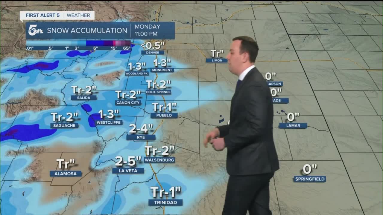
Colorado Springs forecast: High: 27; Low: 12. Cold and cloudy today with snow arriving in the mid to late afternoon and falling through the evening. We could see banded snow in northern El Paso County and south of downtown from Fountain through the Pueblo/El Paso County line. Areas of banded snow could get closer to the 2 inch accumulation mark, but downtown will probably see an inch or less.
Pueblo forecast: High: 31; Low: 9. We'll see snowy and slick roads in the morning from snow overnight and early today. More snow will fall late today and tonight with light accumulations through the evening. We could see a heavier band of snow develop north of Pueblo along I-25 near the El Paso/Pueblo county line, so be careful on the evening commute home from Colorado Springs.
Canon City forecast: High: 31; Low: 17. We have light snow with snow-covered and slick roads early today. Snow will fall this afternoon and accumulate through the early evening. Banded snow could form along Highway 50 from Canon City east to the Pueblo County line, and within that band 2 inches will be possible. Canon City should generally expect 2 inches or less through this evening.
Woodland Park forecast: High: 30; Low: 7. Cold and snowy on the roads with more snow this afternoon and early this evening. We'll see accumulations range from 1 to 3 inches through the evening.
Tri-Lakes forecast: High: 20s; Low: >10. Cold and snowy on the roads this morning with another shot of light snow late today and tonight. We could get a snow band to set up in northern El Paso County that drops around 1 to 3 inches of snow.
Plains forecast: High: 30s; Low: 10s. Cold with a little snow from last night on the roads this morning. We could see weak snow showers blow east of I-25 late today and this evening but accumulation should stay very low, generally under 1 inch in Crowley and Otero Counties.
Walsenburg and Trinidad forecast: High: 30s; Low: 10s. Snowy and icy commutes are possible this morning, especially if you're traveling north to Pueblo. We'll see another shot of light snow this evening but from Walsenburg to Trinidad the snow accumulations should generally stay at one inch or less.
Mountains forecast: High: 20s; Low: >10. Snowy mountain commutes are expected this morning from what fell on Sunday. We'll see another shot of snow along the Front Range, Wets, and Sangres through the evening. We could get another 2 to 4 inches in the Wet Mountains with another few inches down the Sangre De Cristos.
Extended outlook forecast:
Tuesday could be a little slick in the morning, depending on how much snow falls tonight, and we'll be very cold with morning temperatures in the teens and the single digits.
Tuesday afternoon should be dry but cold and breezy through the afternoon.
The next chance for snow arrives Wednesday night through Thursday morning with highs in the 30s on Wednesday and highs in the teens on Thursday.
____
Watch KOAA News5 on your time, anytime with our free streaming app available for your Roku, FireTV, AppleTV and Android TV. Just search KOAA News5, download and start watching.
