


Today’s Forecast:
We're in for a cold, cloudy, gloomy, and wet Memorial Day across southern Colorado.
Rain will start over the mountains between 12 to 2 pm, and move to the interstate between 3 to 4 pm. Rain could be heavy in and around the mountains & valleys with small hail and flooding as our main concerns. Storms along and east of I-25 will not be severe, but heavy rain and isolated areas of small hail are still possible.
Highs will hit the 50s or low 60s for most of the region, so dress warm and pack a rain jacket if you're headed out to cemeteries and memorial services in the afternoon.
COLORADO SPRINGS: High: 54; Low: 42. Cloudy and generally dry other than a quick and weak spotty shower before lunch, but heavy rain and a few rumbles of thunder will be possible in the mid-afternoon. Rain timing is likely around 2 to 3 pm and will continue till after 6 pm when the skies start to dry up.
PUEBLO: High: 60; Low: 46. Cloudy and dry other than a stray sprinkle before noon. Rain which could be heavy, will move in by 3 pm and continue to fall until around 7 pm this evening.
CANON CITY: High: 57; Low: 46. Cloudy and cold today with rain and a few rumbles of thunder after lunch. Rain start time is likely around 2 pm this afternoon, and it could be heavy.
WOODLAND PARK: High: 48; Low: 36. Cloudy and cold with snow up over tree line in the mountains of Teller County, but rain down where we all live. Rain could be heavy with small hail as the only threat. Storms would be likely around 1 to 2 pm.
TRI-LAKES: High: 40s; Low: 30s. Cloudy and cold with rain moving back anytime after 1 pm and leaving the Tri-Lakes around 6 pm this evening. Small hail is possible with heavy rain, but severe threats are low.
PLAINS: High: 60s; Low: 40s. Cloudy and cold today with highs in the 60s and showers and storms likely moving east of the interstate anytime after 3 to 4 pm. We could see storms through 8 to 9 pm tonight, but we should be dry by 9 to 10 pm. Severe weather is not expected today.
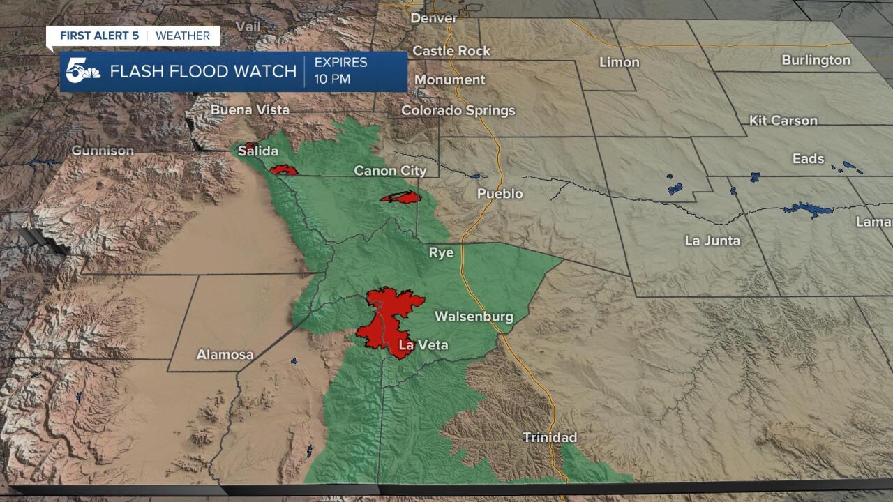
WALSENBURG/TRINIDAD: High: 50s; Low: 40s. Morning rain with more rain in the afternoon and evening. The heaviest rain will fall west in the mountains and there could even be snow over La Veta Pass. Rain will move back into the interstate around 3 to 4 pm with dry skies after 8 pm tonight.
MOUNTAINS: High: 40s; Low: 30s. We could see strong storms with heavy rain, small hail, and flooding through the afternoon. Snow will be possible over the mountains today, but mainly at or above tree-line. Flooding threats are greatest on the burn scars and areas that saw heavy rain over the weekend.
Extended Outlook:
We should start Tuesday with brighter skies and dry conditions, but rain and thunderstorms will move back in through the afternoon. Storms could be strong tomorrow, and more flooding in the high country will be our primary concern along with small hail.
We should see drier skies through the end of the week, but isolated mountain storms on Wednesday and especially Thursday will be possible. A few isolated storms could wander in the Pikes Peak Region Thursday, but Pueblo and the plains look dry.
Friday looks sunny, hot, and dry but storms will move back in by the weekend, especially Sunday.
KOAA News5 on your time, streaming on your Roku, FireTV, AppleTV and AndroidTV.
News5 App | First Alert 5 Weather App | Youtube | Facebook | Instagram | Twitter
