

Tonight's Forecast:
Temperatures will remain consistent with what we have seen over the past few nights. Overnight lows will be in the 30s and 40s for I-25 and the eastern plains. The mountains will have some cooler lows with temperatures reaching the 20s and 30s.
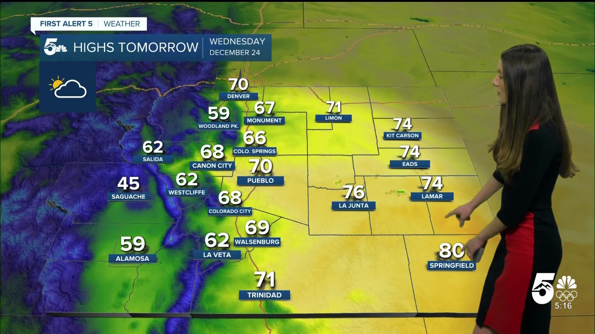
Colorado Springs forecast: Low: 39; High: 66;
Colorado Springs will wake up to lows in the upper 30s. A stubborn layer of clouds will continue to stay in the area as this next system moves out east. The Springs will stay dry throughout the day. Afternoon highs will be in the mid-60s.
Pueblo forecast: Low: 36; High: 70;
Pueblo will have overnight lows in the mid-30s. Clouds will prevent us from getting too cold overnight. This cloud layer will stay across the area. Tomorrow's highs will be in the 70s. If you have any outdoor Christmas Eve plans it will be a nice day for it. You will even be able to ditch the heavy coat.
Canon City forecast: Low: 41; High: 68;
Canon City will be in the lower 40s during the morning of Christmas Eve. It will be a great day for any outdoor Christmas Eve plans. Highs in the afternoon will be in the upper 60s. Clouds will remain across the area during the day.
Woodland Park forecast: Low: 36; High: 59;
Woodland Park will have some chilly temperatures on Christmas Eve morning. Throughout the day temperatures will rise in the upper 50s. This is very much above average for this time of year. Clouds will remain across the area. Take advantage of these nicer conditions because cooler temperatures arrive over the weekend.
Tri-Lakes forecast: Low: 38; High: 67;
Monument will have morning lows in the upper 30s. Winds will remain light throughout throughout the day between 5 and 10mph. A stubborn cloud layer will remain in the area. Highs during the afternoon will be in the upper 60s.
Plains forecast: Low: 30s; High: 70s & 80s;
The plains will have lows n the 30s tomorrow morning. By the afternoon these temperatures will be in the 70s and even 80s further south. There will be sunshine throughout the day with just a few clouds.
Walsenburg and Trinidad forecast: Low: 46/41; High: 69/71;
The southern I-25 corridor will be warm overnight with lows in the mid-to-lower 40s. More clouds will stay in the area. Highs in the afternoon will be in the upper 60s and lower 70s. Winds will remain between 5-15mph.
Mountains forecast: Low: 20s & 30s; High: 40s & 50s;
The mountains will be chilly overnight with lows in the 20s and 30s. Clouds will remain in place as this next system brings snow towards the end of the day. Highs will make it into the 40s. Snow levels will remain around 9,000 feet. Snow moves in much later after dinnertime.
Extended outlook forecast:
Looking ahead, snow continues for the mountains through Saturday. Highest totals will be closer to Wolf Creek Pass. The ski resorts look to pick up a couple of inches. Snowpack is still on the lower side. I-25 has a small chance of getting some light snow around Saturday. Chances remain on the lower side, but it is something we are continuing to watch.
____
Curious about the First Alert 5 Weather Storm Impact Scale? Check out our cheatsheet explainer.
Watch KOAA News5 on your time, anytime with our free streaming app available for your Roku, FireTV, AppleTV and Android TV. Just search KOAA News5, download and start watching.
