


Tonight's Forecast:
Santa will have temperatures in the 40s and 50s by the time he arrives to southern Colorado. Temperatures will reach lows in the 40s by the early morning hours of Christmas Day.
Tomorrow's Forecast:
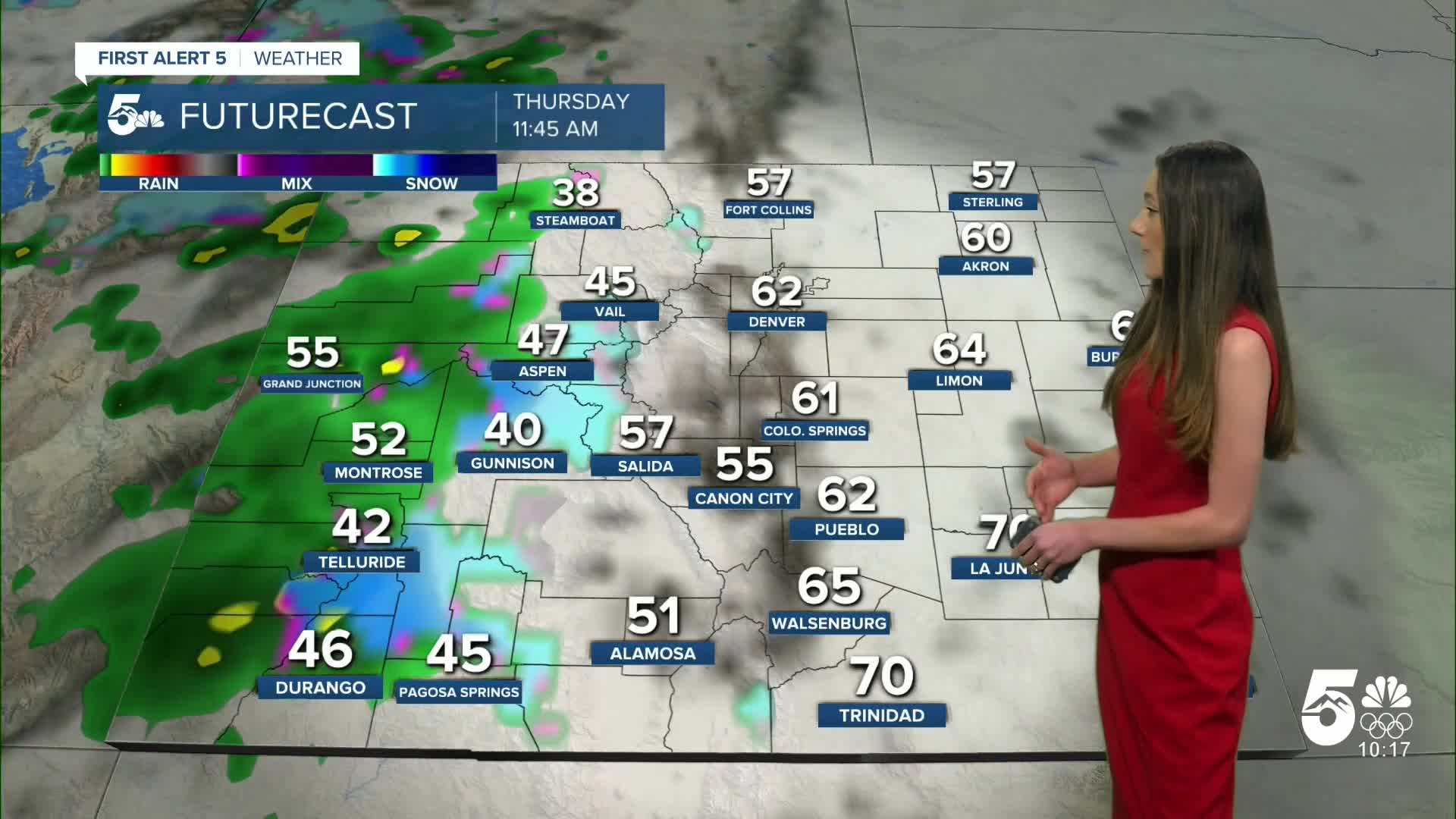
The all time highest temperature that we have reached in Colorado Springs on Christmas Day is 67 degrees. Our forecast high has us tied with that record, but there is still a chance of breaking that. Pueblo also has a record of 72 degrees, and that is also the forecast high. Mostly clear conditions will last throughout the day with mostly cloudy conditions.
Colorado Springs forecast: Low: 41; High: 67;
Christmas Day for Colorado Springs will be very nice, especially for any outdoor activities. Highs will be in the upper 60s. Overall, this is very unusual for this time of year. If you are looking forward to some colder conditions that will arrive over the weekend.
Pueblo forecast: Low: 40; High: 72;
Pueblo will have overnight lows in the 40s. Highs by the afternoon will be in the lower 70s. There is still a possibility of this being the all-time warmest Christmas Day on record for Pueblo. Cloudy conditions will be in place with a little bit of sunshine peaking through.
Canon City forecast: Low: 47; High: 71;
Canon City will wake up to temperatures in the upper 40s. Mostly cloudy conditions will remain throughout the day, but the sun will still be present. Highs during the afternoon will be in the lower 70s.
Woodland Park forecast: Low: 35; High: 59;
Woodland Park will have a chilly Christmas morning in the 30s. Don't be fooled by these temperatures because by the afternoon highs will be closer to 60 degrees. Mostly cloudy conditions will start off the day and clouds will slowly move out of the area throughout the day.
Tri-Lakes forecast: Low: 43; High: 72;
Christmas Day will have lows in the 40s and warmer temperatures will arrive by the afternoon. Highs will be in the lower 70s.
Plains forecast: Low: 30s & 40s; High: 70s;
The plains will have 30s and 40s in the morning and afternoon highs will be in the 70s. There will be mostly cloudy conditions throughout the day with lighter winds.
Walsenburg and Trinidad forecast: Low: 50/45; High: 70/72;
The southern I-25 corridor will have warm overnight lows only making it into the 40s and 50s. Temperatures will continue to rise and by the end of the day highs will be in the lower 70s. Winds will remain light.
Mountains forecast: Low: 30s; High: 50s;
The mountains will have the coldest temperatures in the 30s. Highs later on in the day will be in the 50s. Colder temperatures won't arrive until the weekend. Snow will continue through the day and end closer to Friday morning.
Extended outlook forecast:
Looking ahead, we are tracking a mixup in our warm pattern. A strong cold front will move through Friday and bring cold temperatures and more moisture. The new model runs have really amped up this system and Colorado Springs and I-25 have a good shot at getting some snow. It remains around 30-40% for the I-25 corridor. This is something the first alert weather team is keeping a close eye on.
____
Curious about the First Alert 5 Weather Storm Impact Scale? Check out our cheatsheet explainer.
Watch KOAA News5 on your time, anytime with our free streaming app available for your Roku, FireTV, AppleTV and Android TV. Just search KOAA News5, download and start watching.
