

Tonight's Forecast:
Temperatures will be slow to cool over the next few hours. 70s will arrive by 9PM for most of southeastern Colorado. Overnight lows will be in the 60s for I-25 and the Plains.

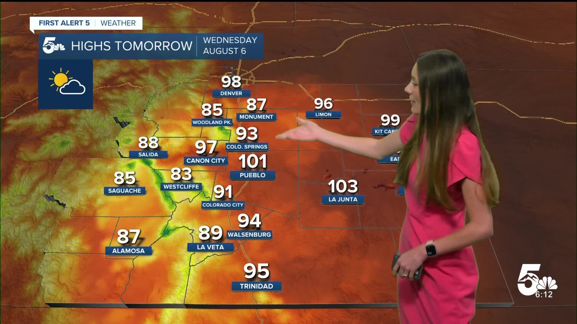
Above-average temperatures will continue into Wednesday with highs once again reaching the 90s and 100s. Some smoke and haze will be present during the afternoon, but will clear out later in the day.

Colorado Springs forecast: Low: 61; High: 93;
Colorado Springs will have temperatures in the upper 80s through 7PM. Some smoke and haze will also be present through the overnight hours and into tomorrow. Highs will reach the lower 90s by the afternoon.
Pueblo forecast: Low: 63; High: 101;
Pueblo will have more smoke and haze move into the area overnight. Temperatures will cool into the lower 60s. Highs will get into the 100s in the afternoon. Some clouds will move into the area later on in the afternoon.
Canon City forecast: Low: 63; High: 97;
Canon City will be slow to cool this evening with temperatures reaching the 70s closer to 9PM. These temperatures will eventually reach a low of 63 degrees. The heat will return again tomorrow with highs reaching the upper 90s.
Woodland Park forecast: Low: 54; High: 85;
Woodland Park is also feeling the heat with 80s continuing into the forecast. Overnight lows tonight will drop into the mid-50s. By tomorrow afternoon, these temperatures will be in the mid-80s again. These temperatures are going to last the next couple of days.
Tri-Lakes forecast: Low: 61; High: 87;
Monument will eventually drop into the lower 60s by the early morning hours on Wednesday. By the afternoon, highs will be in the upper 80s. The warmest day of the week will be Thursday. Some relief from the heat will arrive on Saturday.
Plains forecast: Low: 60s; High: 100s;
The Plains will have the warmest temperatures in southeastern Colorado with highs over the next few days staying in the triple digits. A few clouds will move into the area tomorrow afternoon, but won't help too much with the heat. Some smoke and haze will also be possible from the wildfires in western Colorado.
Walsenburg and Trinidad forecast: Low: 62; High: 94/95;
The southern I-25 corridor will have overnight lows in the lower 60s. Wednesday's highs will be in the mid-90s. This heat wave is expected to continue through Friday. In this time heat related illnesses will become more likely.
Mountains forecast: Low: 50s; High: 80s;
The mountains will have Red Flag Warnings through 8PM this evening. Dry conditions are expected to continue throughout the week with these warmer temperatures. Highs will be in the 80s across the higher terrain on Wednesday.
Extended outlook forecast:
A heat advisory will be in effect starting Thursday at 11Am and lasting through 8PM. This is when we will likely see our warmest temperatures. We are tracking a cold front that is expected to move through the area over the weekend. This will increase our rain chances, especially towards Sunday.
____
Curious about the First Alert 5 Weather Storm Impact Scale? Check out our cheatsheet explainer.
Watch KOAA News5 on your time, anytime with our free streaming app available for your Roku, FireTV, AppleTV and Android TV. Just search KOAA News5, download and start watching.
