

Today’s Forecast:
We've seen a few areas of heavy snow overnight and some of the pavement is holding snow. The worst morning drives will be north from Monument to Castle Rock, over the Wet Mountains, and way down south near La Veta, Cuchara, and La Veta Pass.

We'll keep seeing periods of snow this morning with more snow moving back in through the afternoon south in our southern mountains and out east into the plains through Las Animas, Baca, and southern Bent counties. The graphic above shows how much more snow is expected by the end of the day today.
Snow will diminish in the Pikes Peak Region this morning but additional snow will actually push in from the south later today. We'll be dry tonight but cold with lows in the 20s.
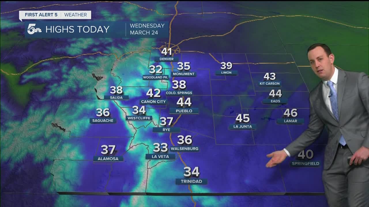
COLORADO SPRINGS: High: 38; Low: 22. Snow will decrease and stop through the morning in the Pikes Peak Region, but the roads around the Air Force Academy and Monument to Castle Rock will remain snowy and slushy past the morning commute. More snow showers will be possible in the afternoon, but mainly for areas west of I-25 into the foothills. Not much accumulation is expected this afternoon with dry and cold conditions moving in overnight.
PUEBLO: High: 44; Low: 23. A few flurries are possible through the morning but Pueblo will probably stay pretty dry for most of the day. As snow moves in from the south this afternoon a few showers are possible after 2 pm, but that chance is more likely south and east of Pueblo. We'll be dry and very cold tonight.
CANON CITY: High: 42; Low: 25. Areas of snow through the morning but with most of the accumulation happening south of Canon City into the Wet Mountains and over towns like Beulah. Highway 50 should stay wet today and even if we see brief rain to snow showers this afternoon there won't be any accumulation in Canon City.
WOODLAND PARK: High: 32; Low: 16. Periods of moderate snow in the morning with more snow from lunch through the afternoon. We could see another couple of inches of accumulation in the daytime, but the roads should warm enough to try to keep the pavement wet to slushy after the lunch hour. We'll be dry and very cold tonight.
TRI-LAKES: High: 30s; Low: 10s. Moderate to heavy snow through the morning commute with mostly dry skies by lunchtime. We could see a stray snow shower in the afternoon but no real additional accumulation is expected after 8 am today. Tonight will be cold and we could see a bit of ice on wet to slushy pavement.
PLAINS: High: 40s; Low: 20s. Snow and rain push in from the New Mexico border around and after lunch today with snow falling mostly south of Highway 50 in Las Animas County. We'll see rain on the north edge of the snow since temperatures will be warm, but Highway 160 could see a few inches of accumulation this afternoon. We'll be dry overnight and it could get icy on a few small roads.
WALSENBURG/TRINIDAD: High: 30s; Low: 10s. Periods of snow through the morning with slushy commutes from Walsenburg to Trinidad. More rain to snow will push in from the south around and after the lunch hour, but the heaviest accumulations will be south of Trinidad through Raton Pass. Around 1 to 3 inches could fall from Trinidad south to Raton Pass, with more over the pass itself through the afternoon.
MOUNTAINS: High: 30s; Low: 20s. Periods of heavy snow today over the Wet and Sangre De Cristo mountains, especially in the morning. We'll see a second push of snow this afternoon, mainly over the southern Sangres, and that means La Veta Pass could be slick again for the evening commute.
Extended Outlook:
We'll see dry skies overnight with only a small chance for stray rain to snow showers in Teller County on Thursday. There's a chance for rain and snow Friday afternoon through Friday night, but snow accumulation looks pretty weak across the region. The weekend looks dry and much warmer by Sunday with a small chance for rain and snow Tuesday from Monument Hill north to Denver.
KOAA News5 on your time, streaming on your Roku, FireTV, AppleTV and AndroidTV.
News5 App | First Alert 5 Weather App | Youtube | Facebook | Instagram | Twitter
