



Tonight's Forecast:
Tonight, rain and clouds will continue for parts of southern Colorado. Some areas along I-25 will see the rain pick back up early tomorrow morning. Overnight lows will be in the 40s, 50s and 60s.
Tomorrow's Forecast:
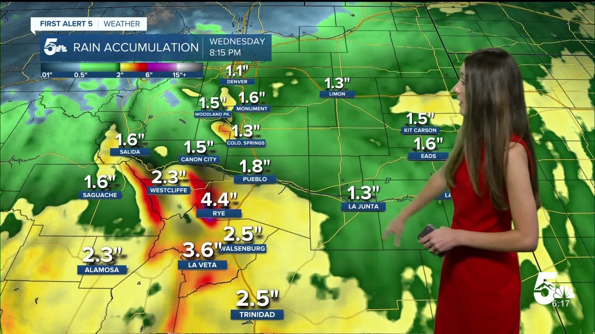
Our active weather pattern begins tomorrow, but the bulk of the rain will arrive in the afternoon. Temperatures won't warm too much with the layer of clouds that will stick around during the day. There are a couple of areas that will get concerning amounts of rainfall. The wet mountains in particular look to receive a couple of inches.
Colorado Springs forecast: Low: 54; High: 64;
Colorado Springs will get some breaks from the rain overnight. Clouds will continue, and rain will eventually pick back up in the afternoon and evening. Flood watches are in place through Thursday. Highs will be in the 60s.
Pueblo forecast: Low: 57; High: 69;
Pueblo will have temperatures in the upper 50s overnight. Rain will become heavy at times, especially in the afternoon and evening. This moisture is coming from a hurricane off in the Pacific. Highs will be cooler in the upper 60s.
Canon City forecast: Low: 58; High: 67;
Canon City will have overnight temperatures in the upper 50s. Rain will continue overnight and over the next few days. It will become heavy at times. A flood watch is in place through Thursday. Highs on Tuesday will be in the upper 60s.
Woodland Park forecast: Low: 44; High: 55;
Woodland Park will have temperatures overnight in the 40s. Temperatures won't warm too much because of the cloudy and rainy conditions. Rain will continue overnight and throughout the day on Tuesday.
Tri-Lakes forecast: Low: 51; High: 59;
Monument will dip into the lower 50s overnight. Clouds will stick around during the day and there will be more rain that pushes into the area. Higher rain accumulations will come later in the day. Afternoon highs will get into the upper 50s.
Plains forecast: Low: 50s & 60s; High: 60s & 70s;
The eastern plains will have overnight lows in the 50s and 60s. Rain will stop overnight and there will be some clouds in the morning. Most of the heavy rain arrives overnight Tuesday and into early Wednesday morning. Highs on Tuesday will be in the 60s and 70s.
Walsenburg and Trinidad forecast: Low: 55/56; High: 63/67;
The southern portion of I-25 will have some of the highest rainfall totals over the next few days. The wet mountains will have a couple inches of rainfall through Thursday. Flood watches have been put into place through Thursday. Highs on Tuesday will be in the 60s.
Mountains forecast: Low: 40s; High: 60s;
The mountains will have some heavy rain over the next few days. Unfortunately, for anyone wanting to go leaf peeping these conditions will not be ideal. The next chance for some sunshine will be on Friday.
Extended outlook forecast:
Expect rain to continue through Thursday, but these chances will be lower than Wednesday. Temperatures will start to warm back up towards the weekend, and there will be more sunshine. It may take a few days to see trails and other areas dry out.
____
Curious about the First Alert 5 Weather Storm Impact Scale? Check out our cheatsheet explainer.
Watch KOAA News5 on your time, anytime with our free streaming app available for your Roku, FireTV, AppleTV and Android TV. Just search KOAA News5, download and start watching.
