

Tonight's Forecast:
Overnight, smoke will push into Fremont county and the southern portion of Teller county. It looks like the majority of the smoke will stay out of El Paso and Pueblo counties, but don't be surprised if the smell lingers. Temperatures will dip into the 30s and 40s.
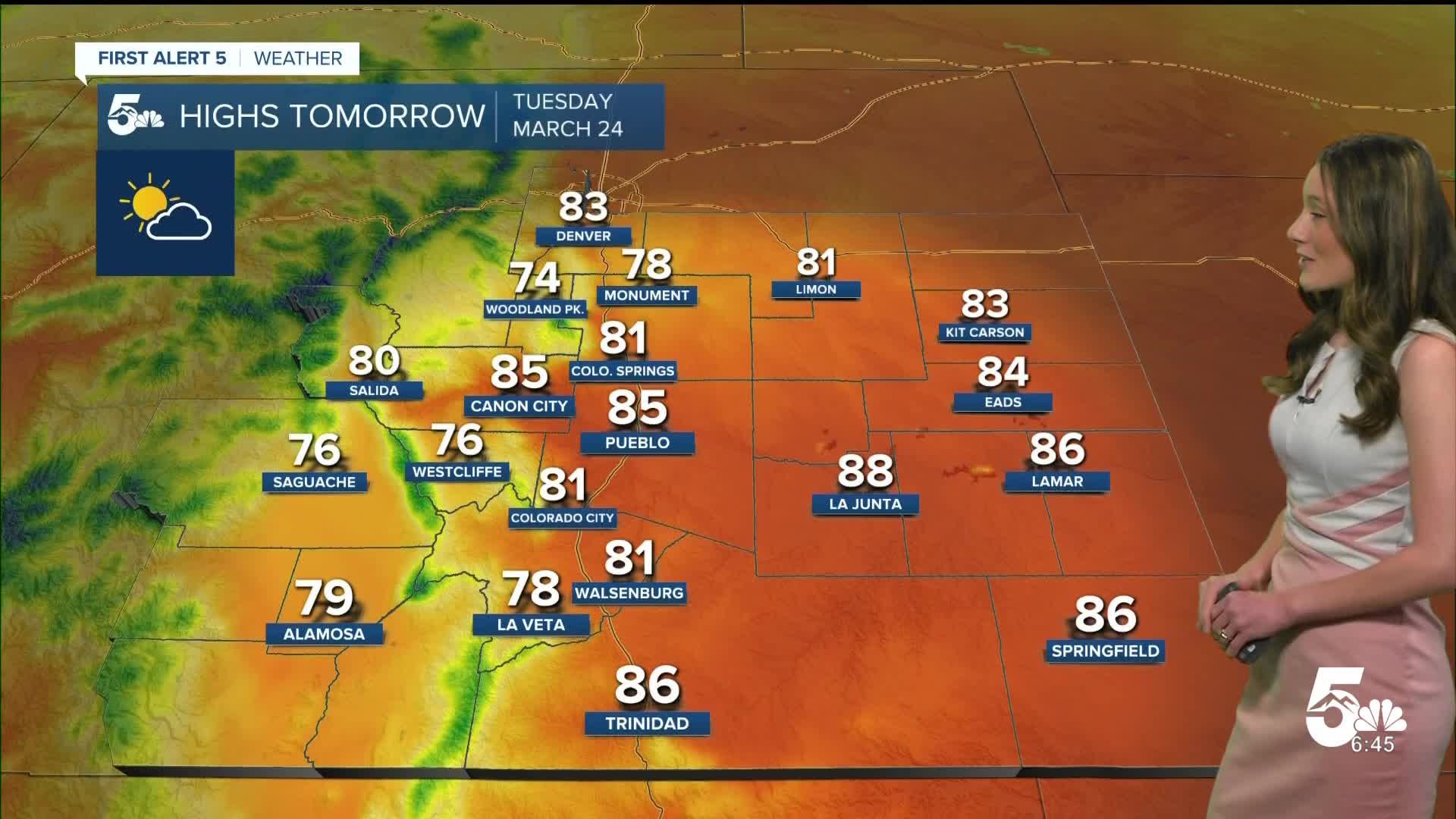
Colorado Springs forecast: Low: 44; High: 81;
Colorado Springs will begin their stretch of record breaking temperatures. Afternoon highs will be in the lower 80s. It does look likely that these records tomorrow will be broken because the previous record is 74 degrees. Smoke and haze will still be pushed up against the mountains, but the haze and smell will linger.
Pueblo forecast: Low: 42; High: 85;
Pueblo will reach the lower 40s overnight. Afternoon temperatures will also likely break records with our forecasted high getting into the mid-80s. The previous record is 82 degrees. There will be a few clouds, but plenty of sunshine.
Canon City forecast: Low: 45; High: 85;
Canon City will continue to have smoke push into the area and across Fremont county. That will last overnight and into tomorrow. The heat will start to settle in with highs reaching the mid-80s.
Woodland Park forecast: Low: 40; High: 74;
Woodland Park will have morning temperatures in the 40s. There will also be a possibility of some smoke as well. The thickest portion of smoke will be in southern Teller county, and this will move during the day. Afternoon highs will be warm in the mid-70s.
Tri-Lakes forecast: Low: 45; High: 78;
The Monument area will dip into the mid-40s overnight. Temperatures will quickly rise, and will be in the lower 60s by 10am. Highs will top out in the upper 70s. There is still a chance for some smoke to linger.
Plains forecast: Low: 30s; High: 80s;
The eastern plains will calm down with the winds overnight and will be calmer tomorrow. Morning temperatures will be in the 30s, but by the afternoon these temperatures will be in the 80s.
Walsenburg and Trinidad forecast: Low: 45/41; High: 81/86;
The southern I-25 corridor will get into the 40s overnight and tomorrow morning. There will be a few clouds in the area, but there will still be plenty of sunshine. Afternoon temperatures will be in the lower-to-mid 80s.
Mountains forecast: Low: 30s & 40s; High: 70s & 80s;
The mountains and higher terrain will have smoke overnight and temperatures will be in the 30s and 40s. By the time we get into the afternoon temperatures will be in the 70s and 80s.
Extended outlook forecast:
Record breaking temperatures will be possible over the next few days. Tuesday through Thursday will have the warmest temperatures this week. A cold front will move through and drop highs on Friday. With this front there is a chance for some moisture along with it. There are still some uncertainties, and right now it looks like this will mainly impact the higher terrain.
____
Curious about the First Alert 5 Weather Storm Impact Scale? Check out our cheatsheet explainer.
Watch KOAA News5 on your time, anytime with our free streaming app available for your Roku, FireTV, AppleTV and Android TV. Just search KOAA News5, download and start watching.
