

Tonight's Forecast:
Tonight, there will be a few clouds that stick around after today's thunderstorms. Temperatures will make into the 40s for I-25 with some cooler temperatures for higher elevations. Winds will calm down overnight before picking up again on Sunday.
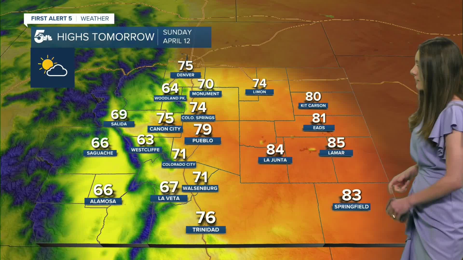
Colorado Springs forecast: Low: 42; High: 74;
Red flag warnings will be in place from 11AM-9PM due to gusty winds and dry conditions. There will be a few clouds during the day, but no rain is expected. Highs will be warm, making it into the 70s by the afternoon.
Pueblo forecast: Low: 43; High: 79;
Pueblo will have morning temperatures in the lower 40s. Winds will pick up in the late morning and humidity values will get as low as 7%. Red flag warnings will be in place tomorrow, so avoid any outdoor burning. Afternoon highs will be in the upper 70s.
Canon City forecast: Low: 43; High: 75;
Canon City and Fremont county will have temperatures dip into the lower 40s overnight. Partly cloudy skies will remain, but still a good amount of sunshine. Highs going into tomorrow afternoon will be in the mid-70s. Fremont county will be in a red flag warning until 9PM on Sunday.
Woodland Park forecast: Low: 35; High: 64;
Woodland Park will have some cooler temperatures overnight, dipping into the mid-30s. There will be a few clouds during the day, and highs will be in the mid-60s. It will be a nice day to get outside, just be cautious of fire danger.
Tri-Lakes forecast: Low: 40; High: 70;
The Monument area will wake up to temperatures in the lower 40s. By 10AM, temperatures will be in the upper 50s. It will be a very nice day to get outside with only a few clouds. Highs headed into tomorrow afternoon will be in the lower 70s.
Plains forecast: Low: 40s & 50s; High: 80s;
Thunderstorms will wind down overnight, and only a few clouds will remain. Even though these thunderstorms dropped some moisture onto the ground, fire danger will be back in the forecast on Sunday. Highs in the afternoon will reach the 80s.
Walsenburg and Trinidad forecast: Low: 44/43; High: 71/76;
The southern I-25 corridor will have morning temperatures in the mid-to-lower 40s. The morning looks to start off with mostly clear conditions, but there will still be some clouds during the day. Afternoon highs will be in the lower-to-mid 70s. Red flag warnings will be in place until 9PM.
Mountains forecast: Low: 30s; High: 60s;
The mountains will have some stronger gusts tomorrow, especially towards the peaks. Morning temperatures will get into the 30s, but by the afternoon highs will be in the 60s. There is still a small chance for an isolated shower in the central mountains in the afternoon.
Extended outlook forecast:
Fire danger returns on Monday and Fire Weather Watches have been put into place. Our next system arrives on Tuesday with rain chances increasing in the afternoon. By Wednesday, conditions clear out. The next unsettled pattern arrives at the end of the week.
____
Curious about the First Alert 5 Weather Storm Impact Scale? Check out our cheatsheet explainer.
Watch KOAA News5 on your time, anytime with our free streaming app available for your Roku, FireTV, AppleTV and Android TV. Just search KOAA News5, download and start watching.
