

Tonight's Forecast:
Tonight, there will be some scattered showers in southern Colorado. A few of these storms will have some heavier rainfall, gusty winds, and lightning. Overnight temperatures will drop into the 40s and 50s. Clouds will continue to push out of the area overnight and into the plains.
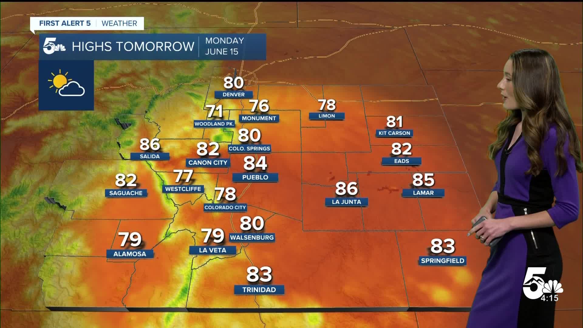
Tomorrow's Forecast:
The morning will be nice with some clouds continuing to clear out. We will have mostly sunny skies throughput the day. With some leftover moisture an isolated shower is possible across the southern I-25 corridor and parts of the plains. Highs will be a couple of degrees warmer than Sunday.
Colorado Springs forecast: Low: 48; High: 80;
Colorado Springs will have overnight lows in the 40s. The showers and thunderstorms that we saw this evening will be gone by the morning and the clouds will have moved out too. There will be partly cloudy skies during the day and highs will reach the lower 80s. Winds will be coming out of the southeast at 5mph.
Pueblo forecast: Low: 52; High: 84;
Pueblo will have overnight lows in the lower 50s. Clouds will exit the area by 8am. Temperatures will eventually warm into the mid-80s. Winds will be calm during the day and will be coming out of the southeast.
Canon City forecast: Low: 54; High: 82;
Canon City will start the day off with mostly clear conditions and calm winds. Lows will be in the lower 50s, and afternoon highs will be in the lower 80s.
Woodland Park forecast: Low: 44; High: 71;
Woodland Park will clear out overnight and temperatures will get down into the mid-40s. Winds will continue to be calm throughout the day on Monday. By the afternoon, temperatures will be a few degrees warmer than Sunday. Highs will reach the lower 70s.
Tri-Lakes forecast: Low: 46; High: 76;
Monument will have overnight lows in the mid-40s. The clouds will clear out by 9AM, but will return later on in the day. Afternoon highs will be in the mid-70s. Conditions will be nice with calm winds coming out of the south. There is a small chance for an isolated shower, but the majority of the area will stay dry.
Plains forecast: Low: 50s; High: 80s;
The eastern plains will still have some clouds into the morning from this exiting system. Some areas may even have some leftover showers slowly pushing into Kansas. Lows across the area will drop into the 50s.
Walsenburg and Trinidad forecast: Low: 51/50; High: 80/83;
The southern I-25 corridor will have overnight temperatures in the lower 50s. There will be a few clouds lingering in the morning, but no rain is expected. Conditions clear out later in the morning. Afternoon highs will be in the lower 80s. There will be a chance for an isolated thunderstorm in the afternoon.
Mountains forecast: Low: 40s; High: 70s;
The mountains will have overnight temperatures in the 40s. There will be some breezy conditions during the day. Winds will be coming out of the northwest between 15 and 20mph. Highs will reach the 70s.
Extended outlook forecast:
Highs each day will continue to warm with the hottest temperatures arriving on Wednesday. A few areas will approach record-breaking territory. A cold front moves in on Thursday and will cool us back down. Rain chances look to be on the lower side since conditions will still be so dry. Rain chances will pick up into the weekend.
____
Curious about the First Alert 5 Weather Storm Impact Scale? Check out our cheatsheet explainer.
Watch KOAA News5 on your time, anytime with our free streaming app available for your Roku, FireTV, AppleTV and Android TV. Just search KOAA News5, download and start watching.
