



Today’s Forecast:
We have some gusty winds that will move in today and will last throughout the majority of the day. High wind warnings are in place for Huerfano county and some areas in the mountains. Gusts in this area have the chance of reaching 65mph. Along I-25, gusts won't be quite as strong, but there will still be a few gusts that reach 50mph near the Pikes Peak Region.
Colorado Springs forecast: High: 60; Low: 27.
Winds will be gusty today, especially as we get into the afternoon. Gusts have the possibility of approaching 50mph in the Pikes Peak Region. Today will be the last warm day before temperatures drop over the weekend. Highs today will reach the lower 60s.
Pueblo forecast: High: 65; Low: 31.
Pueblo is chilly this morning with temperatures back in the 20s and 30s. This will be the final big warm up before an impactful cold front brings cooler temperatures to the area. Afternoon highs will reach the 60s. There will be some gusty winds over I-25 today and might make travel difficult for high-profile vehicles.
Canon City forecast: High: 62; Low: 32.
Canon City is sitting in the 40s and 50s this morning. This will change once the weekend arrives. For today, highs will reach the lower 60s. Winds will be quite strong coming out of the southwest around 40mph. There will be some isolated stronger gusts over the area. Lows on Saturday morning will drop into the 30s.
Woodland Park forecast: High: 50; Low: 23.
Woodland Park is waking up to temperatures in the 20s and 30s. Some mid-level cloud cover has moved in and will stick around during the day. Afternoon highs will be warm for this time of year in the 50s. Winds will be gusty throughout the day.
Tri-Lakes forecast: High: 53; Low: 23.
Monument and northern El Paso county is chilly this morning with temperatures in the 30s. This is the last day of seeing a big afternoon warm up before temperatures drop. Afternoon highs will reach the lower 50s. Winds will be strong today with gusts reaching closer to 50mph at times.
Plains forecast: High: 60s & 70s; Low: 30s.
The eastern plains will also have some gusty winds later on this morning and last into the afternoon. Highs will get into the 60s and 70s. The warmest temperatures will be located along highway 50.
Walsenburg and Trinidad forecast: High: 58/65; Low: 30/32.
High wind warnings are in place for Hueranfo county today. This area will have the strongest winds across southern Colorado today. Gusts in the mountains could range from 65-75mph. Closer to I-25 gusts may approach 65mph. Winds aren't expected to calm down until later this evening. Highs will be in the 50s and 60s.
Mountains forecast: High: 50s; Low: 20s.
The mountains will have some snow move in and along with that gusty conditions will last throughout the day. Afternoon highs will make it into the 50s for the lower elevations.
Extended outlook forecast:
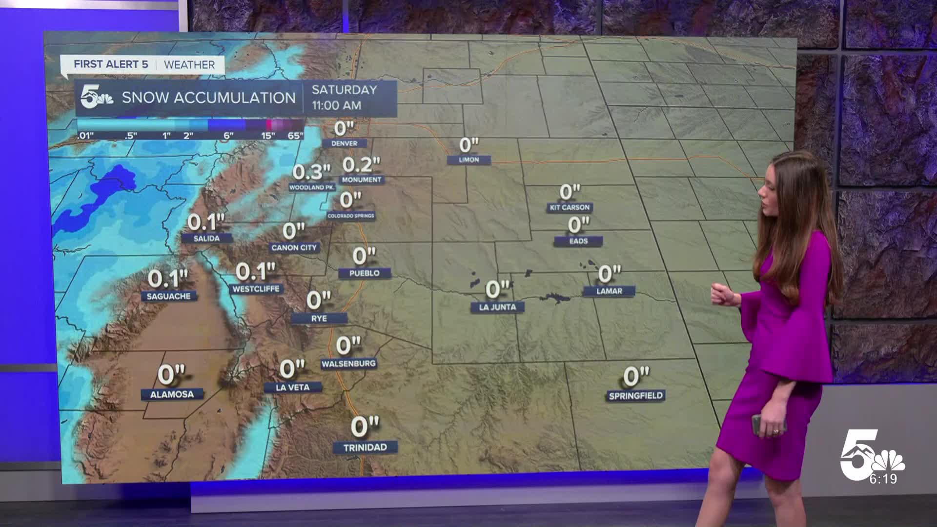
Looking ahead, a cold front drops across southern Colorado and will bring some much colder air. Snow will be possible across Teller county, but a few flurries could make their way to the northern portion of El Paso county. This system doesn't look overly impressive and snowfall rates would have to be quite high in order to see accumulations along I-25. A dusting on grassy surfaces is still possible Saturday morning. These temperatures will be very similar throughout the next several days. Next week looks to remain in those 40s.
____
Curious about the First Alert 5 Weather Storm Impact Scale? Check out our cheatsheet explainer.
Watch KOAA News5 on your time, anytime with our free streaming app available for your Roku, FireTV, AppleTV and Android TV. Just search KOAA News5, download and start watching.
