



Today’s Forecast:
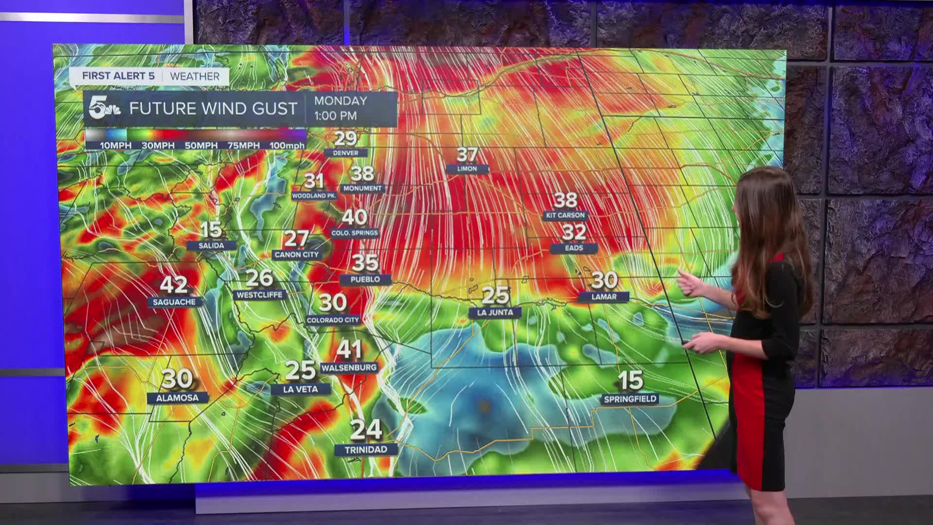
A cold front will move across Southern Colorado and bring windy and wet conditions. The rain will move in around 11AM/Noon for Colorado Springs and the Pikes Peak Region. Windy conditions will also pick up around the same time. Areas closer to eastern El Paso county will approach 40-50mph wind gusts. Afternoon temperatures will reach the mid-50s. Rain will start to calm in the late afternoon and evening.
Colorado Springs forecast: High: 53; Low: 34.
Colorado Springs will have lows this morning in the 40s. Cloud cover and rain chances will increase towards the later half of the morning and into the early afternoon. On top of the rain chances, windy conditions will pick up around the same time. Sustained winds will be around 20mph while gusts will be much stronger approaching 40-50mph. Temperatures this afternoon will reach the lower 50s.
Pueblo forecast: High: 59; Low: 38.
Pueblo will start the day with temperatures in the 40s. Afternoon highs will get into the upper 50s. We are tracking a more active pattern today that will bring rain and wind to Pueblo. Wind gusts will be between 30-40mph. Rain will move in around noon and last into the afternoon. Rain will wrap up by the time we get into the late evening. Morning lows on Tuesday will be a few degrees cooler in the upper 30s.
Canon City forecast: High: 59; Low: 37.
Canon City will have lows this morning in the 50s. Temperatures will continue to rise and by the afternoon highs will get into the lower 50s. Rain chances will increase later on this morning and mainly in the afternoon. As this cold front pushes east winds will increase closer to 30-40 mph.
Woodland Park forecast: High: 44; Low: 28.
Woodland Park will have chilly morning temperatures this week in the 20s and 30s. The afternoon temperatures will still warm into the 50s later on today. As this low continues to exit the state we will see winds pick up and moisture arrive to Teller county. There will be a mix of snow and rain towards the higher elevations today. This moisture clears out in the evening and overnight.
Tri-Lakes forecast: High: 47; Low: 31.
Monument is sitting in the 40s this morning. We are tracking more moisture and windy conditions later on today. Winds will eventually shift out of the north and gusts will have the chance of reaching 40-50mph. Rain chances will increase throughout the late morning and early afternoon.
Plains forecast: High: 60s; Low: 20s.
The eastern plains will have temperatures in the 40s and 50s this morning. By the afternoon highs won't rise to much, especially with rain moving in. Wind gusts will be on the stronger side with some areas approaching 50mph. Rain will be heavy at times and will eventually move out overnight.
Walsenburg and Trinidad forecast: High: 54/58; Low: 20s.
The southern portion of I-25 will have afternoon temperatures in the mid-to-upper 50s. Rain pushes in during the early afternoon and will continue throughout the day. Windy conditions will continue into Tuesday.
Mountains forecast: High: 40s & 50s; Low: 20s.
The mountains will have temperatures this morning in the 30s. Rain is currently moving through the western side of the state, but that will eventually move east. Rain, snow and wind will be possible throughout the day today. Highs will reach the 40s and 50s.
Extended outlook forecast:
Tuesday will clear out, but windy conditions will remain. Highs will be consistent throughout the week and only change by a degree or two. There will be another chance of some rain in the middle of the week. Wednesday evening will have these rain chances increase. Thursday and onward looks nice with sunny conditions remaining in the forecast.
____
Curious about the First Alert 5 Weather Storm Impact Scale? Check out our cheatsheet explainer.
Watch KOAA News5 on your time, anytime with our free streaming app available for your Roku, FireTV, AppleTV and Android TV. Just search KOAA News5, download and start watching.
