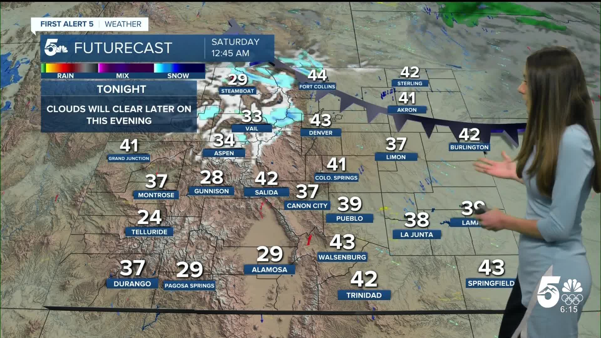


Tonight's Forecast:
A cold front will make its way south throughout the night and get to El Paso county around 4-5AM. Winds will pick up and become breezy around 15-25mph.
Tomorrow's Forecast:
Some breezy conditions will linger throughout the day, but the strongest winds will be towards the eastern plains. Some winds will approach 30-4mph. I-25 will not get that gusty. Temperatures will be a few degrees cooler due to a cold front.
Colorado Springs forecast: Low: 32; High: 54;
Clouds will thin out overnight and help temperatures to approach freezing. Highs will be a couple of degrees cooler and will drop below average. Mid-50s will arrive by the afternoon. Gusts will get up to 25mph at their strongest. Mostly clear conditions will last throughout the day.
Pueblo forecast: Low: 30; High: 57;
Pueblo will have some gusty conditions earlier on, but not nearly as strong as this w=past week. Morning lows will be below freezing. By the afternoon, clear skies won't be much help and highs will only make it into the upper 50s.
Canon City forecast: Low: 36; High: 56;
Canon City will have overnight temperatures drop into the mid-30s. Clouds will also clear out and afternoon highs will be in the mid-50s. Winds will pick up at times between 15-20mph.
Woodland Park forecast: Low: 27; High: 50;
Woodland Park will start the day off with temperatures in the upper 20s. The cold front will only allow highs to get into the upper 50s. Not much moisture with this cold front, so no snow yet. Clouds will also clear out throughout the overnight hours.
Tri-Lakes forecast: Low: 29; High: 52;
Monument will be chilly to start on Saturday with morning lows in the upper 20s. When the sun rises temperatures will steadily rise into the 40s around 9am. Highs will be in the lower 50s.
Plains forecast: Low: 30s; High: 50s & 60s;
The eastern plains will have the strongest wind gusts which will approach 40mph at times. Highs later on in the afternoon will be in the 50s and 60s. The warmest temperatures will be closer to highway 50.
Walsenburg and Trinidad forecast: Low: 35/34; High: 55/57;
The southern I-25 corridor will have morning lows in the mid-to-lower 30s. Winds will be around 15-25mph throughout the day. This cold front will cause highs to only reach the mid-to-upper 50.
Mountains forecast: Low: 30s; High: 50s;
The higher terrain will have overnight lows in the 30s. Clouds will continue to clear out. Saturday will also be clear and temperatures will be in the 50s.
Extended outlook forecast:
The extended forecast still looks boring with another ridge of high-pressure arriving by the beginning of the week. Temperatures will get back into the 70s. A few clouds will move in towards the end of the week.
____
Curious about the First Alert 5 Weather Storm Impact Scale? Check out our cheatsheet explainer.
Watch KOAA News5 on your time, anytime with our free streaming app available for your Roku, FireTV, AppleTV and Android TV. Just search KOAA News5, download and start watching.
