

Today’s Forecast:
Periods of rain and snow will fall from Denver down through southern Colorado today, only getting worse as we move from the afternoon into the overnight hours. The heaviest snow will fall in the mountains and Monument Hill from late today through the overnight hours. Temperatures will fall pretty much all day into a hard freeze overnight. Read below for more details.
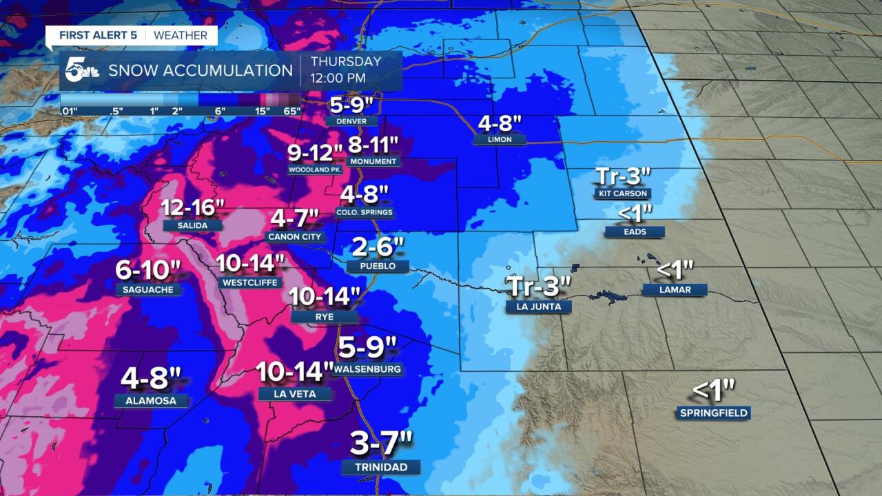
COLORADO SPRINGS: High: 34↓; Low: 26. Windy with steady and falling temperatures tonight into a hard freeze overnight. We could see showers mixed with snow at times today, but most of our snow will not happen until tonight, mainly sometime after 6 pm. The bulk of our snow will accumulate in the grass, but once the pavement gets to freezing late tonight, we will see snow stick to the roads and our commutes could get bad overnight into Wednesday morning. 4-8 inches of snow is very likely across town by Wednesday morning.
PUEBLO: High: 40↓; Low: 30. Windy with constantly cooling temperatures all day into a hard freeze overnight. Unfortunately, this will likely mean the end to our growing season and a possible kill to most of the chili crop. We'll see flakes and showers during the day but the bulk of our snow won't fall until tonight. We'll get snow to collect in the grass first, but when the pavement drops to freezing late tonight, there could be a couple of inches by Wednesday morning.
CANON CITY: High: 39↓; Low: 32. Windy and chilly all day with cooling late-day temperatures into a freeze tonight. We'll see a mix of showers and snow during the day but the main action will happen from the end of the day through the overnight hours. There will be some very heavy snow in the mountains of Fremont County and especially out west of 50 near Salida. Canon City could see 4 to 7 inches of snow overnight into early Wednesday morning.
WOODLAND PARK: High: 27↓; Low: 20. Freezing for most of the day today but temperatures will fall into a deep and hard freeze by Wednesday morning. We'll see lighter snow in the morning with heavy snow showing up in the afternoon and overnight hours. Pavement temperatures will drop to freezing in the second part of the day and most of our accumulation will start falling fro the late day through the overnight hours. This will be a very slick late day and overnight drive for anyone who needs to go to work, as 9-12 inches of snow is likely by Wednesday morning.
TRI-LAKES: High: 30↓s; Low: 20s. Windy and cold with temperatures steady and falling pretty much all day down to a hard freeze overnight. We'll see flurries and snow showers today, but the pavement will not fall to freezing until later this afternoon. The heaviest snow is going to fall late today and tonight, and we're likely to see anywhere from 8 to 11 inches by Wednesday morning, probably a bit more west by Palmer Lake and the foothills.
PLAINS: High: 40↓s; Low: 20s. Cold and windy all day with rain and snow. Temperatures will fall to a hard freeze, but one or two areas might stay a degree above 32. We'll see a mix of rain and snow, possibly freezing rain, overnight for most areas east of El Paso and Pueblo counties. What snow we do get in the plains will generally stay on the low side, but there could be a few inches that stacks up in western Otero and Crowley counties. Tonight's freeze could very well kill most crops.
WALSENBURG/TRINIDAD: High: 40↓s; Low: 20s. Windy with steady and falling temperatures into a hard freeze tonight. We'll see periods of rain and snow today, but the bulk of our snow along I-25 will not show up until late day and tonight. There could be very slick drives from Walsenburg to Trinidad and especially out west along La Veta Pass by tomorrow morning. The mountains west of I-25, like in and around La Veta, could easily see over a foot of snow later today and tonight.
Extended Outlook:
We will see leftover snow early Wednesday morning but we'll get drier through the afternoon, other than a few stray showers and flurries. We'll get more showers and flurries late Wednesday night to Thursday morning, and we'll be dry Thursday afternoon. The weekend looks warm and dry.
