TONIGHT: Areas of showers and even a few thunderstorms push through this evening and overnight. The best chance for thunder will be for the eastern plains. Most locations get a bit of a break after midnight before showers return in the morning. Highs for Wednesday will actually occur at midnight for most locations and then temperatures will fall throughout the day.
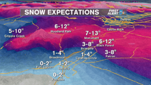
WEDNESDAY: Showers return during the early morning hours. These will start as rain for the lower elevations and change to wet and heavy snow throughout the morning. The main focus for snow will be El Paso and Teller counties up through the Denver Metro. These areas will have the highest totals, with a wide range in place.
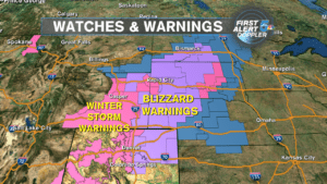
The snow will be coupled with intense winds. Gusts around 60 – 70 mph will be possible. The strongest winds start around 10 am and will produce blizzard conditions with whiteout conditions as well as blowing and drifting snow for those areas seeing the heaviest snow.
High winds will be the main concern for areas south of Colorado Springs. These winds will be strong enough to potentially cause damage to trees, power lines, roofs, etc for all areas along and east of the mountains.

Snow and blizzard conditions will persist through the evening commute, primarily focused on the Palmer Divide, before trying to taper off overnight.
IMPACTS:
-Travel: Expect major travels delays throughout the day. Roads over the Palmer Divide and east to west roads will have the biggest impacts with difficult to near impossible conditions. East to west roads will have an intense crosswind, likely blowing snow onto the roadways. Roads over the Palmer Divide will have the highest snow totals and the greatest concern for drifting and low visibility. It will be a good day to work from home if you can. If you absolutely have to travel, have a full tank of gas, plenty of time, and an emergency kit in case you get stranded.
-Schools: Expect a lot of closures, especially around Teller and El Paso Counties. The ride in might not be bad in the morning, but conditions will deteriorate during the day. Closures have already been coming into the newsroom. Find the latest list here.
-Airports: Both Colorado Springs and Denver International are included in Blizzard Warnings. Expect big delays and cancellations for incoming and outgoing flights, especially after 10 am. Check the flight status before attempting the trip!
COLORADO SPRINGS: Low – 37, High – 42. Isolated showers this evening and tonight. Rain changing to wet heavy snow on Wednesday with blizzard conditions developing. Highest totals of 4-8″+ will be focused on northern areas heading towards the Palmer Divide. Travel will be dangerous the farther north you go. Totals will taper off quickly towards the southern end of town.
PUEBLO: Low – 41, High – 49. Shower and thunderstorms will be around this evening and tonight. Mainly rain showers at times tomorrow with some changeover to snow possible. Accumulations, if any, will be minor. Wind will be the bigger concern with gusts over 60 mph.
CANON CITY: Low – 41, High – 49. Isolated mainly rain showers this evening. Chance for rain changing to snow tomorrow with gusty winds. Accumulations will be minor, but blowing and drifting is still possible.
WOODLAND PARK: Low – 31, High – 33. Rain/snow showers will be around this evening and tonight. Heavy wet snow and gusty winds tomorrow. At least 4-8″ of accumulation with dangerous travel conditions.
TRI-LAKES: Low – 30’s, High – 30’s. A few showers this evening. Rain changing to heavy wet snow tomorrow with blizzard conditions and dangerous travel. 5-10″ will be possible with significant blowing and drifting.
PLAINS: Low – 40’s, High – 50. Showers and thunderstorms move through this evening and overnight. A few rain to snow showers tomorrow with little to no accumulations. Winds will be the bigger issue with gusts over 60 mph.
WALSENBURG/TRINIDAD: Low – 40’s, High – 40’s. Areas of showers and thunderstorms this evening and tonight. Strong winds tomorrow with areas of rain to snow at times.
REST OF THE WEEK: Any lingering snow by Thursday morning will be confined to the Palmer Divide and will taper off quickly. Clouds, cold, and wind will still be around. Expect delays to linger for the morning commute as we dig out. The rest of the week is looking much better. Sunshine returns in abundance on Friday and lasts through the weekend. Temperatures will be on a warming trend with highs in the 50’s by the weekend.
