Tonight’s Forecast:
Skies continue to clear this evening and overnight. Fog could develop for some locations, especially those that still have decent snow on the ground. Temperatures stay bitterly cold. Lows will again be in the negatives for many locations with wind chills even further below zero. Any areas that had melting with the afternoon sun could refreeze overnight so slick spots are again possible.
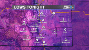
COLORADO SPRINGS: Low – -3, High – 39. Clearing skies and frigid lows tonight. Sunshine and milder temperatures tomorrow.
PUEBLO: Low – -5, High – 42. Clear and very cold tonight. Areas of fog will be possible. A bright day with improving temperatures Wednesday.
CANON CITY: Low – -3, High – 38. Mainly clear and cold tonight with areas of fog. Sunshine tomorrow with miler temperatures.
WOODLAND PARK: Low – -5, High – 32. Mainly clear and bitterly cold tonight. More sunshine and milder Wednesday.
TRI-LAKES: Low – -0’s, High – 30’s. Clearing skies and bitter temps tonight. Sunny tomorrow with milder highs.
PLAINS: Low – 0’s, High – 40’s. Clear and cold overnight. A milder Wednesday with sunshine.
WALSENBURG/TRINIDAD: Low – 0, High – 30’s. Mainly clear and very cold tonight. Areas of fog possible. Sunny tomorrow with better temperatures.
REST OF THE WEEK: Sunshine will be abundant for the short work week as temperatures rebound. Despite a chilly start, we’ll improve to 40’s for most areas on Wednesday. 50’s return for the second half of the week and continue into the weekend. A few low 60’s could pop up for our warmest locations throughout this time period. A little more cloud cover in the mix for Sunday and Monday with mountain snow possible. We look mainly dry at the lower elevations for now.
