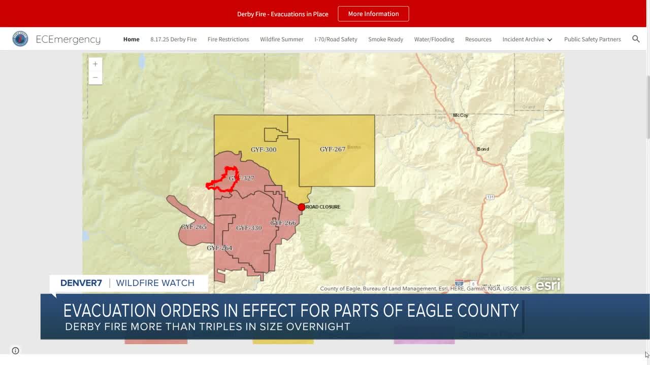


EAGLE COUNTY, Colo. — Mandatory evacuation orders have been issued for some residents in Eagle County after the 839-acre Derby Fire exploded in growth overnight, deputies with the Garfield County Sheriff's Office said Wednesday morning.
Residents of Sweetwater Road and areas of Colorado River Road from Sweetwater to Red Dirt Creek were advised to evacuate their homes by noon Wednesday.
Derby Mesa Loop remains in pre-evacuation at this time, according to Eagle Valley Wildland.
Residents in the area were advised to head to the Eagle County Public Safety Information website for an up-to-date evacuation/pre-evacuation map.
The Eagle County blaze, burning about 15 miles north of Dotsero in the White River National Forest, was sparked by lightning on Saturday.
There have been no reports of structural loss or injuries.
Scripps News Denver is tracking several other wildfires on Colorado's Western Slope. Below is a summary of those fires:

Size: 137,755 acres
Containment: 68%
First reported: Aug. 2
Cause: ⚡️
Location: 18 miles southwest of Meeker
Evacuations 🏠: For the most up-to-date evacuation map, click here.
Pre-evacuations: For the most up-to-date pre-evacuation map, click here.
The lightning-sparked Lee Fire, first reported on Aug. 2, is burning 18 miles southwest of Meeker in Rio Blanco County.
Three homes and 12 outbuildings have burned so far in the Lee Fire, according to officials in Rio Blanco County, who said firefighters made steady progress on the north side of the fire and continued to work along Hogback Ridge Thursday.
Over the weekend, the Rio Blanco County Sheriff’s Office downgraded several evacuation zones from GO (red) to SET (yellow) and from SET to READY (green).
The Garfield County Sheriff’s Office downgraded Zone 70 on the east side of Highway 13 in northern Garfield County from GO (red) to SET (yellow). Other zones have not changed.
Crews are continuing to clean up remaining interior pockets of unburned fuel, creating a more uniform black footprint. Firefighters will patrol the fire perimeter and increase mop-up depth where possible along the fire lines, according to Wednesday update.
The Rio Blanco County Sheriff's Office said a partial closure of the White River National Forest was also in effect due to the fire within the Blanco Ranger District west of and including the Long-Lost Trail system.
Updates posted to:
Elk and Lee Fire Information
Rio Blanco County Sheriff's Office
InciWeb

Size: 2,067 acres
Containment: 23%
First reported: Aug. 11 at 3:25 pm.
Cause: Unknown
Location: Routt National Forest in Rio Blanco County
Evacuations 🏠: See a map of the evacuation zones here
As of Wednesday morning, the Crosho Fire was threatening 67 structures, according to the Wyoming Type 3 Incident Management Team. However, none had been destroyed as of 9 a.m.
Pre-evacuations remains for residents along County Road 90 to the north, County Road 92 to the west, parts of Highway 131 to the east and just north of Milk Creek to the south.
Closures remain in effect for the following roads:
- Intersection of Routt County Road 15 and Routt County Road 17
- Intersection of Routt County Road 25 and Routt County Road 132A
- Rio Blanco County Road 8 (Dunckley Pass) closed at intersection of Rio Blanco County Roads 8 and 19
Fire officials said Wednesday containment is increasing thanks to the hard work of firefighters cold trailing, mopping up, and strengthening lines around the fire’s perimeter. Progress remains steady despite hot and dry weather, rugged terrain and overhead hazards.
An emergency closure order is in place for the Medicine Bow-Routt National Forests around the fire. The Routt County Emergency Incident Map is updated with road closures.
Updates posted to:
InciWeb
Crosho Fire Information
Rio Blanco County Sheriff's Office

Size: 9,407 acres
Containment: 10%
First reported: July 28
Cause: ⚡️
Location: 5 miles west of Rico in the San Juan National Forest
Evacuations 🏠: No current evacuations
Fire officials said Wednesday that warm and dry conditions were expected to persist in the area before dry thunderstorms move in by the afternoon on both Wednesday and Thursday, which could create lightning starts as well as gusty outflow winds of up to 35-40 mph.
"With low relative humidities, the potential for active fire behavior exists," fire officials said in a Wednesday update.
Firefighters were cautioned to remain vigilant when working in canyons, especially Stoner Creek canyon, where rolling material can ignite receptive fuels below and cause sustained uphill runs.
To sign up for Dolores County emergency alerts, click here. To sign up for Montezuma County emergency alerts, click here.
Updates posted to:
Stoner Mesa Fire Information
USDA Forest Service Facebook page
InciWeb

Size: 31,698 acres
Contained: 79%
First reported: July 10
Cause: ⚡️
Location: 8 miles northeast of Gateway in Mesa County
Evacuations 🏠: All evacuation orders have been lifted
In a Wednesday update, fire officials said crews were employing dynamic strategies to address increased fire activity caused by "exceptionally dry" daytime conditions and low overnight humidity.
Firefighters continue to patrol existing containment lines and cool hot spots, especially along the southern perimeter of the fire.
Crews have completed repair work on Niche Road and repairs on 402 and 406 roads are expected to be completed on Thursday, fire officials said.
A monsoon system is slowly working into the fire area, and winds continue to be favorable at 9 mph and lower, with occasional gusts up to 17 mph, fire officials said.
Updates posted to:
InciWeb
Turner Gulch Fire Info.
Upper Colorado River Interagency Fire Management Unit Facebook
Mesa County Sheriff's Office page on Facebook

Blue Ridge Fire
Size: 25 acres
Containment: 100%
First reported: Aug. 15
Cause: Under investigation
Location: La Plata County
Notes: All evacuation and pre-evacuation orders lifted on Aug. 18.
Oak Fire
Size: 75 acres
Contained: 78% (as of last update on Aug. 13)
First reported: Aug. 10
Cause: Structure fire
Location: Archuleta County west of Pagosa Springs
Notes: The Archuleta County Sheriff's Office said two suspects have been arrested in connection with an illegal burn that started this fire. The suspects have been identified as Sergio Alaniz Jr., 41, and Ross Heirigs, 60. They were arrested on charges of fourth-degree arson.
Peninsula Fire
Size: 17 acres
Containment: 80% (as of last update on Aug. 10)
First reported: Aug. 8
Cause: ⚡️
Location: South of Highway 145, between Norwood and Placerville
Yellowjacket Fire
Size: 29 acres
Contained: 40% (as of last update on Aug. 16)
First reported: Aug. 15
Cause: Unknown
Location: Northeast of Meeker
Deer Creek Fire
Size: 17,724 Acres
Containment: 100%
First reported: July 10
Cause: Under investigation (as of last update on Aug. 12)
Location: Eastern Utah and Montrose County (Colorado)
South Rim Fire
Size: 4,232 Acres
Containment: N/A (National Park Service says 100% containment likely will not occur until snowfall, but "fire behavior is limited to smoldering and creeping, and poses very little risk of spread outside the current fire footprint.")
First reported: July 10
Cause: ⚡️
Location: Black Canyon of the Gunnison National Park
Leroux Fire
Size: 195 Acres
Containment: 100%
First reported: Aug. 3
Cause: ⚡️
Location: Delta County
Wright Draw Fire
Size: 466 acres
Containment: 100%
First reported: July 10
Cause: ⚡️
Location: Mesa County
Windy Gap Fire
Size: 30 acres
Containment: 100%
First reported: Aug. 6
Cause: Unknown
Location: Grand County
___

Why budget flights are hard to find at Colorado Springs Airport and what's being done
The shutdown of Spirit Airlines is sending ripple effects through the airline industry.
____
Watch KOAA News5 on your time, anytime with our free streaming app available for your Roku, FireTV, AppleTV and Android TV. Just search KOAA News5, download and start watching.
