


Read Friday's update on the Cameron Peak Fire here.
...
LARIMER COUNTY, Colo. — Firefighters at the Cameron Peak Fire are continuing to make “excellent progress” around the perimeter of the fire, according to the Interagency Wildland Fire Air Quality Program.
The most active section of the 102,596-acre fire on Wednesday was the Green Ridge area along Highway 14, officials said. This region of the fire has a steep slope and dry and dead beetle-kill trees.
However, firefighters were able to make progress on the fire line here with the help of aerial crews. The containment remains at 8%.
The contingency lines were strengthened on Wednesday in the Crystal Lakes, Red Feather and Glacier View subdivisions, according to the Southwest Area Incident Management Team.
The lines have stayed secure along the fire’s perimeter on the northeastern, eastern and southeastern sides, which includes Highway 14, Pingree Park Road, Long Draw Road and Buckhorn Road to Comanche Reservoir, the team reported.
Fire managers have refined plans for structure protection in Estes Park and Glen Haven, and built indirect lines around the communities, in case they’re needed.
On Thursday, firefighters will continue focusing on constructing direct and indirect fire lines, as well as implementing structure protection. Crews will work on all sides of the fire. Most of the resources are on the northwestern and northern sides, where it’s most active and where winds are continuing to push it.
The incident management team said the fire's perimeter will be tested this weekend as thunderstorms bring gusty, erratic winds to the area. However, the storms will also bring more ideal conditions, including an increase in humidity, lower temperatures and possible rain. The latter weather should help prevent the fire’s spread, fire officials said.
Conditions over the next few days should provide favorable opportunities for continued suppression, according to the Interagency Wildland Fire Air Quality Program.
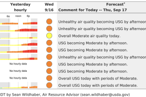
An Action Day Alert is in effect until 4 p.m. Thursday due to poor air quality along the Front Range urban corridor from Douglas County north to Larimer and Weld Counties. This includes the Denver, Boulder, Fort Collins and Greeley areas.
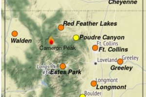
The air quality will be unhealthy in Fort Collins, Greeley and Longmont by the afternoon.
More details are below for the impacted areas.
Multiple mandatory and voluntary evacuations, as well as road closures, are in place around the Cameron Peak Fire. The Larimer County Sheriff's Office said fire officials have downgraded the evacuation status from mandatory to voluntary for Highway 14 from Stove Prairie Landing west to Kelly Flats, and County Road 44H from Pennock Pass to County Road 27. Officials also lifted the voluntary evacuations for Stove Prairie Landing south along County Road 27 to County Road 44H and east to include Stratton Park.
The voluntary evacuation for Glacier View was lifted on Tuesday.
Click here for a full list of evacuations, or explore the map below.
To sign up for emergency alerts in Larimer County, visit NOCO Alert's website here. For updates for people who have been forced to evacuate, text the word LCEVAC to 888777 from your cell phone.
The fire is the fourth-largest in Colorado history. It has surpassed the High Park Fire that damaged hundreds of homes and killed one person in 2012 just east of where the Cameron Peak Fire is currently burning.
The state's 10 largest wildfires in history, ranked by acreage, are:
1. Pine Gulch Fire (2020): 139,007 acres
2. Hayman Fire (2002): 137,760 acres
3. Spring Fire (2018): 108,045 acres
4. Cameron Peak Fire (2020): 102,596 acres
5. High Park Fire (2012): 87,284 acres
6. Missionary Ridge Fire (2002): 72,962 acres
7. 416 Fire (2018): 54,000 acres
8. Bridger Fire (2008): 45,800 acres
9. Last Chance Fire (2012): 45,000 acres
10. Bear Springs/Callie Marie fires (2011): 44,662 acres
(Note: The 2013 West Fork Complex is not included on this list because it was a series of different fires close to one another.)
The fire ignited on Aug. 13 in the Arapaho and Roosevelt National Forests near Cameron Pass and Chambers Lake. Its cause is under investigation. Fire officials said the estimated containment date is Oct. 31.
A statewide open fire ban is in effect for all of Colorado through Oct. 7.
Drones are not allowed to fly around the fire. On Sunday afternoon, a drone was spotted flying in the restricted fly zone near Glen Haven. This caused the officials of the fire's air operations to shift their efforts to the northern portion of the fire until they could confirm that the drone had left the area and would not return.
