


DENVER, Colo. — The Town of Meeker is no longer under a pre-evacuation status as the state's largest wildfire continues to pose a challenge for firefighters on the ground due to hot, dry conditions.
Multiple fires are burning across state and federal lands along Colorado's Western Slope.
More than 127,000 acres of land have burned in separate wildfires in Delta, Dolores, Garfield, Mesa, Moffat, Montrose, and Rio Blanco counties, as well as in parts of eastern Utah, aided by hot and dry conditions which are expected to persist this week.
At least eight of the fires were sparked by lightning, according to fire officials. Most of the Western Slope is under extreme or severe drought conditions, according to the U.S. Drought Monitor.

No lives have been lost, but several structures, including national park infrastructure, have been damaged or destroyed.
Gov. Jared Polis has verbally declared a disaster declaration for several of these fires, which frees up state and federal resources.
Coulter Creek Fire
Size: 107 acres
Containment: 100%
First reported: August 3
Cause: Under investigation; lightning believed to be the likely cause
Location: Carbondale, Colo.
A day after evacuation orders in the Panorama Subdivision, the Ranch at Coulter Creek, and the area east of County Road 100 to Upper Cattle Creek Road were lifted following "aggressive firefighting" on the ground, fire officials said full containment had been reached in the Coulter Creek Fire.
On Monday, fire crews built containment lines and mopped up the fire to make sure it was completely out.
By the afternoon, after announcing the fire had been fully contained, fire officials said firefighters will continue to patrol the fire area over the next few days to watch for any remaining hot spots or flare‑ups.

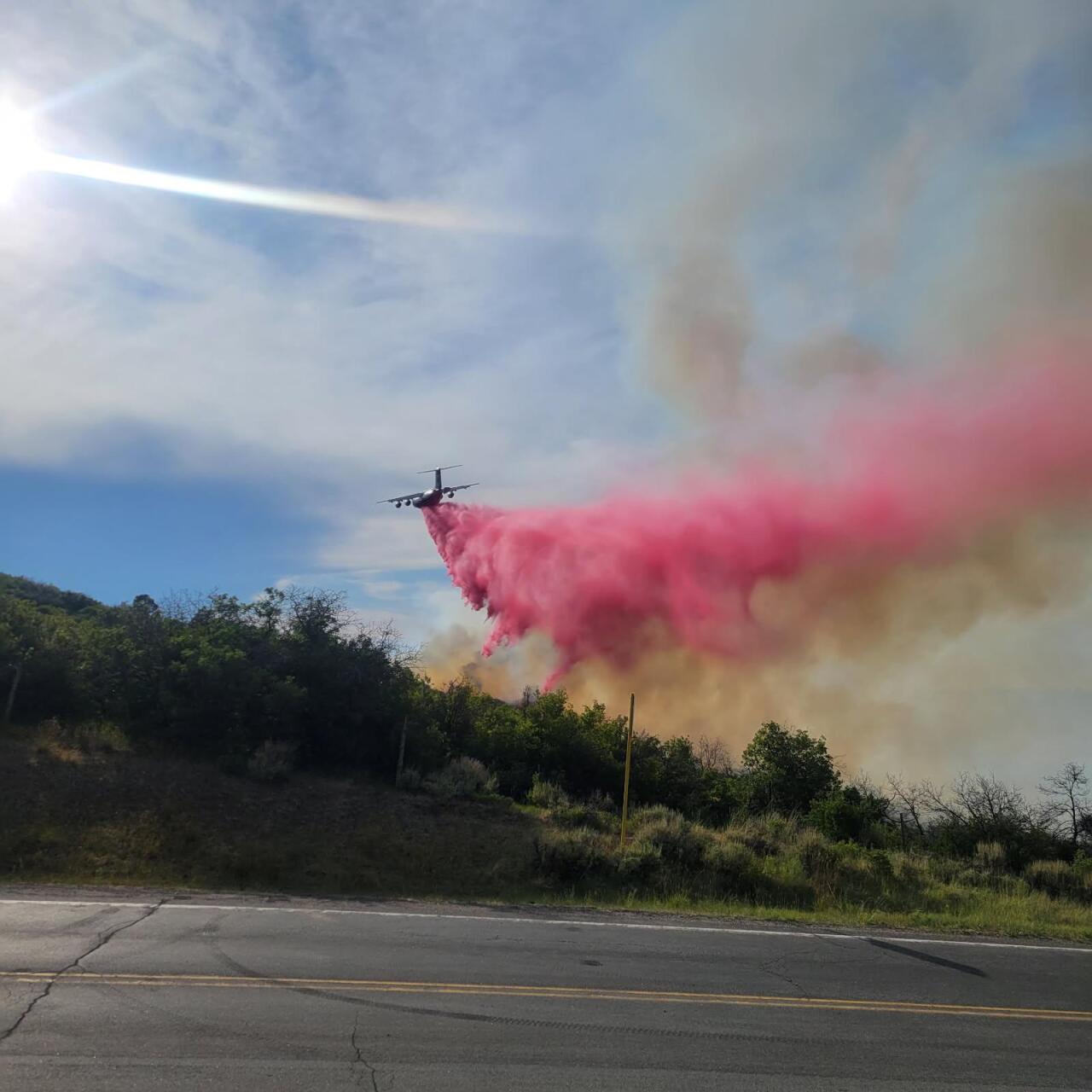
“Firefighters on the ground worked aggressively to build fireline and protect homes while air crews made repeated water and retardant drops to slow the fire’s spread,” said Incident Commander Bill Gavette. “This was a true team effort. Ground crews worked with air crews attacking the fire from multiple angles. That coordinated response was key to stopping the Coulter Creek Fire.”
No homes were lost, though one outbuilding was destroyed in the fire. No injuries have been reported, according to the Carbondale & Rural Fire Protection District.
County Road 113 between County Road 100 and County Road 121 is back open.
Updates posted to:
Carbondale and Rural Fire Protection District
Garfield County Sheriff's Office
Deer Creek Fire
Size: 17,724 acres
Containment: 97%
First reported: July 10
Cause: ⚡️
Location: 1 mile north of Old La Sal
Nearly 600 firefighters are battling the Deer Creek Fire, which is primarily burning in eastern Utah but has also extended into parts of Montrose County.
Areas of San Juan County, Utah, and Montrose County are under an evacuation order. However, some residents who were previously evacuated are returning to their homes, as additional cloud cover and isolated rain showers provided firefighters with favorable conditions last week.

In a Wednesday update, officials said crews will continue to monitor for new starts and address any concerns. Personnel will continue to make progress on the remaining repair work.
There is no information available on any structural loss at this time.
Updates posted to:
InciWeb
Utah Wildfire
Montrose County Sheriff’s Office Facebook
Elk Fire
Size: 14,518 acres
Containment: 0%
First reported: August 2
Cause: ⚡️
Location: 11 miles east of Meeker, off Rio Blanco County Road 8
The Elk Fire remains active and continues to burn in pinyon, juniper and oak brush fuels across private land, state land (Colorado Division of Wildland), and Bureau of Land Management land, according to the Rio Blanco County Sheriff's Office.
Governor Jared Polis on Wednesday mobilized the Colorado National Guard to support response efforts for the Elk Fire and Lee Fire in Rio Blanco County.
As of Aug. 2, evacuation orders were in effect for County Road 8 from mile marker 11 to mile marker 16, impacting both sides of the road; for County Road 40 and County Road 63; for residents living on the north side of the road between Sleepy Cat to Lake Avery; for residents living south of Highway 64 from mile marker 58 trough mile marker 67, including County Roads 127, 66, and Brightwater Lane.
Evacuees can head to the Fairfield Center in Meeker, located at 200 Main Street.
Pre-evacuation notices were in effect for residents from mile marker 16 to mile marker 25 (Avery to Pot Hole Ranch); residents on both sides of County Road 14; those along County Road 57 (Miller Creek); and residents along County Road 8 from mile marker 19 to mile marker 27.

The Elk Fire saw heightened activity Wednesday, with areas of the fire burning together without majorly increasing the footprint of the fire, officials said.
Fire crews will work Thursday to reinforce the line in the west and north side of the fire and continue structure protection.
A red flag warning remains in effect through 8 p.m. Friday, according to the National Weather Service.
County Road 8 from mile marker 10 to 18 is restricted to local traffic only (meaning, only residents who live in the area can use those roads). County Road 4, 13, 22, 33, 36, 66, 76, 127, as well as Highway 13 south are closed in both directions between Piceance Creek Road (15 miles north of Rifle) and Highway 64 (2 miles south of Meeker) from mile Marker 19 to 39. Highway 64 is also closed from County Road 7 to County Road 5 until further notice.
The Rio Blanco County Sheriff's Office said Tuesday afternoon a partial closure of the White River National Forest was also in effect due to the fire within the Blanco Ranger District west of and including the Long-Lost Trail system.
As of Tuesday, one home and four outbuildings have been destroyed by the lightning-caused fire.
Updates posted to:
Rio Blanco County Sheriff's Office
Lee Fire
Size: 60,976 acres
Containment: 0%
First reported: August 3 at 1 p.m.
Cause: ⚡️
Location: 18 miles southwest of Meeker, Colo.
The Lee — formerly known as the Grease Fire — burning southwest of Meeker, is now Colorado's largest wildfire at about 45,000 acres in size.
The fire is burning in pinyon, juniper, grass and brush fuels on both state and Bureau of Land Management lands (BLM) managed by the White River Field Office, according to the Rio Blanco County Sheriff's Office.
Oil and gas infrastructure as well as power infrastructure at risk from the fire, according to BLM officials.
The Town of Meeker is under a pre-evacuation notice due to "the potential for the fire to jump," while residents in areas southwest of Meeker were ordered to evacuate immediately.
As of Aug. 3, evacuation orders were in place for residents on County Road 22 (Little Hills) off of County Road 5; those at the County Road 76 intersection from County Road 3 to County Road 5; and residents along Highway 64 between mile marker 58 and mile marker 67, including those on County Road 127, County Road 129, County Road 66 and Bridgewater Lane.
Pre-evacuation orders are in place for residences on County Road 22 (Little Hills) off of County Road 5, as well as for residents along County Road 33.

The fire was extremely active due to hot, dry, windy conditions on Wednesday, which caused it to jump Highway 13 and rapidly spread over 100 acres before firefighters in the sky could get to the fire to fight its spread, according to fire officials.
Fire crews were working Thursday to stop additional spread on the northeastern part, where it connects to the hogback. As of Thursday evening, the fire is 58,714 acres in size.
County Road 8 remains closed from mile marker 11 to mile marker 19. County Road 3 off County Road 5, County Road 22, County Road 76, and the intersection of County Roads 127 and 129 are closed.
Governor Jared Polis on Wednesday mobilized the Colorado National Guard to support response efforts for the Elk Fire and Lee Fire in Rio Blanco County.
Updates posted to:
Rio Blanco County Sheriff's Office
Leroux Fire
Size: 833 acres
Contained: 74%
First reported: August 3
Cause: ⚡️
Location: 1.5 miles east of Redlands Mesa in Hotchkiss, Colo.
Fire behavior from the Leroux Fire was "greatly reduced" on Tuesday compared to what firefighters were dealing with Sunday and Monday, fire officials said in a Wednesday morning update.
The fire is currently burning near the area of Redlands Mesa and is threatening structures along 3100 Road.
The fire has not grow significantly in acreage since the last update, and no containment was achieved in the last operational period, according to fire officials, who said crews have built dozer lines, removed fire-damaged hazard trees so firefighters can safely work in these areas, and the "cold-trailing" and "mop up" processes are still underway.
A Type 3 and Type 4 team is helping battle the blaze, with a mutual aid task force involving three different fire departments assisting crews on the ground.
Evacuation orders are in effect for residents who live along 3100 Road north of Oak Mesa Road to include the Stoney Mesa subdivision. Fifteen homes have been evacuated, while 152 are under pre-evacuation notice, according to state officials.

The evacuation center is at the Delta County North Fork Annex, located at 196 W. Hotchkiss Ave. in Hotchkiss. Fire officials were working to establish a hotline for the fire.
Roads are closed at 3100 Road and Redlands Mesa Road on the south end of the evacuation zone, according to the Delta County Office of Emergency Management.
Residents who live within the evacuation area and need access to their home to retrieve personal belongings, pets or livestock may be granted access on a temporary basis to retrieve items and evacuate again, officials added.
Residents were advised to text lerouxfire to 65513 to receive updates.
Governor Jared Polis on Monday verbally declared a disaster emergency for the fire in order to support response efforts.
Updates posted to:
InciWeb
Delta County Alerts
Hotchkiss Fire District
West Slope Fire Info
South Rim Fire
Size: 4,232 acres
Contained: 52%
First reported: July 10
Cause: ⚡️
Location: Black Canyon of the Gunnison National Park
Firefighting activity is wrapping up on the South Rim Fire, which is now in a patrol and monitor status under the command of a Type 4 incident management team, according to fire officials on Monday, who added that fire activity remains isolated to interior pockets and inaccessible areas.
In an update from over the weekend, fire officials said suppression repair work had been completed on Friday, and heavy equipment was released from the incident. Crews are demobilizing and traveling home to get a few days off before they’re made available for other fires across the country.
Investigators have also completed their assessments of the fire and delivered their preliminary findings to the National Park Service, the Bureau of Reclamation, and the Bureau of Land Management leadership.
"The most concerning finding was the loss of vegetation in the drainages funneling into the East Portal," fire officials said, adding investigators concluded the fire "significantly impacted the stability of these steep slopes," which could lead to rock fall, mud slides, and debris flows that would pose a serious risk to anyone in the East Portal.
The agencies are exploring options for mitigation of this risk, along with others that were identified during the assessment. “The Park Staff is eager to reopen the South Rim and welcome visitors again, as soon as we can make it safe for the public,” Park Superintendent Stuart West said.
The North Rim of the Black Canyon of the Gunnison National Park is now open, with staff available at the Ranger Station from 10:00 am to 3:00 pm daily.
Visitors to the North Rim will have access to all trails, overlooks, facilities, and the campground. The South Rim of the Park remains closed to the public.
Highway 347 is closed at the National Park boundary.
The South Rim Fire, burning inside Black Canyon of the Gunnison National Park, damaged or destroyed multiple buildings and facilities, including the South Rim Campground and numerous bathrooms and overlooks throughout the park.
The South Rim Visitor Center, the administration building, and the entrance booth were spared from the fire.
Black Canyon of the Gunnison National Park, located primarily in Montrose County, is situated nine miles east of the city of Montrose.
Updates posted to:
Montrose County Sheriff’s Office Facebook
Black Canyon of the Gunnison National Park Facebook
InciWeb
Stoner Mesa Fire
Size: 833 acres
Containment: 0%
First reported: August 5
Cause: Unknown
Location: West of Telluride in Dolores County
A new wildfire was reported on August 5, burning west of Telluride inside the San Juan National Forest in Dolores County.
The Dolores County Sheriff's Office issued an evacuation order for Stoner and Taylor Mesa, directing residents to Highway 145.
This includes Stoner Mesa Road (FS Road 686), Taylor Mesa Road (FS Road 545) as well as all roads branching off, Mavreeso Campground, and West Dolores Campground.

The cause is not known at this time.
Resources on scene include multiple airtankers, an air attack aerial supervision plane, and two helicopters. The fire is burning in a "very remote" area that is inaccessible by foot or road due to "heavy dead and down trees."
In an update Thursday morning, officials said the red flag conditions are expected to drive fire growth throughout the day, as personnel worked to begin scouting the fire area for potential control features including roads, trails, and natural barriers such as rock outcroppings and creeks.
Crews will also begin assessing structures far in advance of the fire out of an abundance of caution, fire officials said.
Updates posted to:
USDA Forest Service Facebook page
InciWeb
Turner Gulch Fire
Size: 27,466 acres
Contained: 49%
First reported: July 10
Cause: ⚡️
Location: 8 miles northeast of Gateway, Colo.
The Turner Gulch Fire, burning off Highway 141 northeast of the town of Gateway in Mesa County, has burned more than 26,000 acres. Ten crews, 8 engines, 12 heavy equipment, and 4 helicopters are battling the blaze, totaling 515 firefighters in all.
No injuries have been reported, and no structures have been lost.
As of noon on July 27, all private lands in the Big Creek and Divide Forks Campground Evacuation Zones have been downgraded to pre-evacuation status, including private inholdings in the Uncompahgre National Forest from Forest Road 406 to 409 (seen as the Cold Springs Evacuation Zone on evacuation maps), as well as all private in-holdings in the Ute Creek Evacuation area, which includes areas in the Uncompahgre National Fores.
People who need help with sheltering large animals should contact (970)778-0161 to be connected with options and resources.

Fire officials said Thursday red flag conditions will be ongoing for the foreseeable future, which will create significant challenges for ground crews.
A contingency group continues to scout potential line locations between the fire and the community of Gateway in case needed, aiming to avoid sensitive areas. Structure protection prep work is now underway after several days of planning, officials said.
On the western edge near private property, crews have not reengaged the fire due to "erratic fire behavior," but are monitoring the area for flare‑ups and are ready to respond if needed, fire officials added.
Along the eastern perimeter of the fire, crews remain focused on patrol, mop‑up, and suppression repair work.
Divide Road remains closed.
Updates posted to:
InciWeb
Mesa County Sheriff’s Office Facebook
Upper Colorado River Interagency Fire Management Unit Facebook
Twelve Fire
Size: 4,287 acres
Contained: 0%
First reported: August 6
Cause: Unknown
Location: Moffat County
The Twelve Fire is burning roughly 18 miles west of Mabell, Colorado, between Elk Springs and the Deer Lodge Park Road.
According to the Bureau of Land Management, the fire is burning across private, state and BLM lands. It is burning in pinyon, juniper, grass and brush.
No homes have been damaged or destroyed so far, but two outbuildings, a shed and an outhouse have been lost, deputies said in an update Thursday morning.

The cause of the fire is not known at this time.
Highway 40 was closed in both directions from mile marker 60 (Maybell) to mile marker 11 near Elk Springs but has since reopened, though there are speed reductions in place due to the fire. Deer Lodge Road is currently closed.
Updates posted to:
Moffat County Sheriff's Office
Windy Gap Fire
Size: 30 acres
Contained: 40%
First reported: August 6
Cause: Likely lightning-caused
Location: Grand County
The Windy Gap Fire burning in Grand County remains at approximately 30 acres in size as firefighters continue to battle the blaze, which fire officials said has so far destroyed five uninhabited small cabins.
Multiple agencies provided fire suppression throughout the day on Wednesday. Two helicopters and a Single Engine Air Tanker (SEAT) were also brought in to help.
Residents in the G41 and G48 zones are under a pre-evacuation status. There are currently no mandatory evacuation orders as of Thursday afternoon.

Highway 40 was closed from Highway 34 to Hot Sulphur Springs, but reopened at 7:30 a.m. Thursday with alternating one-way traffic, deputies said. Highway 125, which was shut down between US 40 and County Road 28, is back open with a flagger controlling traffic, deputies added.
Drivers are encouraged to use Grand County Road 57 or Grand County Road 55 as alternate routes. Commercial motor vehicles (CMV) cannot use those routes and are instead urged to use Interstate 70.
Updates posted to:
Grand County Sheriff's Office
Wright Draw Fire
Size: 466 acres
Contained: 100%
First reported: July 10
Cause: ⚡️
Location: 8 miles northeast of Gateway, Colo.
The 466-acre Wright Draw Fire burned off Highway 141, northeast of the town of Gateway in Mesa County.
No injuries have been reported, and no structures were lost.

Updates posted to:
Upper Colorado River Interagency Fire Management Unit Facebook
Mesa County Sheriff’s Office Facebook
InciWeb

'It Just Kept Getting Bigger and Bigger': A Wildfire Tears Through a Community
A wildfire that started near I-25 swept through the Applewood Mobile Home Park, destroying several homes and forcing a full evacuation. A resident who escaped with his family describes watching as the flames "just kept getting bigger and bigger."
____
Watch KOAA News5 on your time, anytime with our free streaming app available for your Roku, FireTV, AppleTV and Android TV. Just search KOAA News5, download and start watching.
