

It's been a wild year for news in 2020... but we've only had a few notable events in the weather department!
Let's look back at 5 of the biggest weather events this year in southern Colorado.
1. Early September Snow & Cold:

This was probably one of the biggest and craziest weather events of the year.
A dominant heat ridge brought record heat to the state on the 6th and 7th, only for cold air and snow to follow over the following two days!

Colorado Springs set a record high of 97° on the 6th and a record low of 30° on the 8th! Pueblo went from a high of 103° on the 6th to a low of 35° on the 8th.
Click here for a photo gallery of snow pictures from this winter storm.
The biggest swing happened in southeast Colorado near a small town called Ordway.
Temperatures went from 104° on the 7th to a low of 33 on the 9th and 3.9 inches of snow on the ground.
🚨🚨🚨🚨
— ColoClimateCenter (@ColoradoClimate) September 9, 2020
With did some searching, and we found a station in southeast CO that reported 104° on September 7 and 3.9" of snow on September 9.@Climatologist49, obs time is 6am, which means the 104 actually occurred on the 6th, but some of that 3.9" snow likely fell on the 8th. pic.twitter.com/JazEtY3Qom
Ordway and Rapid City, South Dakota both broke a national record of the shortest gap between a 100-degree day and measurable snowfall.
Snowfall records were set with over 12 inches reported around the San Luis Valley and Sangre De Cristo mountains.
The map above shows snow reports from the 8th and 9th of September. Click on the snow icons to see how much snow fell at that particular location.
2. August Hail & Street Flooding in Colorado Springs:
It seems like there's a big hail storm almost every year in Colorado Springs, and 2020 was no exception.
On August 5th, a supercell thunderstorm moved across the south side of Colorado Springs in the mid-afternoon dumping large hail and heavy rain.
Many cars were damaged by hail, and traffic slowed to a stop from flooding in town and on I-25 near south Academy.
Click here for a photo gallery of hail and flooding photos from News 5 Viewers.
While there was hail damage to many cars and some buildings, the total storm cost stayed under the catastrophic insurance industry level of 25 million dollars.
This was some of the heaviest hail I've seen in awhile, and I got smacked pretty good taking this video #COWX @NWSPueblo @KOAA taken at Strawberry Field Grove on Cheyenne Meadows Rd, Colorado Springs pic.twitter.com/q2OV19vejd
— Sam Schreier (@SamASchreier) August 5, 2020
Below is a map of the storm reports from August 5th. Click the icons to see the magnitude of the hail or heavy rain report at that location.
3. Drought Induced Wildfires:

Wildfires were a huge story in Colorado this year, but only a few actually broke out locally.
A lack of Winter/Springs snow and monsoon-driven summer rain pushed the state into extreme drought.

Three of the largest fires in our state's history burned in 2020. The first fire to set that record was the Pine Gulch Fire north of Grand Junction.
Not long after the Cameron Peak and East Troublesome fires erupted.
Those three fires alone burned over 540,000 acres of land in Colorado.
According to the Rocky Mountain Area Coordination Center (RMACC), 1,078 total fires were reported and 625,356 acres of land was scorched.
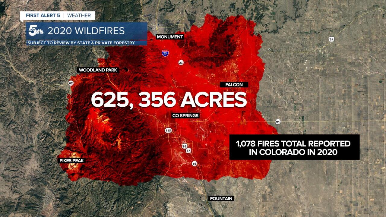
When overlaid over the Pikes Peak Region for visual comparison, 625,356 acres covers all of Colorado Springs and quite a bit of Teller County.
Please note this data could change once the State totals are submitted to State & Private Forestry (USFS) after the new year.
Luckily here in southern Colorado, our fires were much smaller and far easier to control.

The main fires here in our region were the Incline, Bear Creek, Wild Horse, and YMCA Fires.

The Bear Creek Fire, which was incredibly visible in Colorado Springs in late November, threatened homes in the surrounding neighborhoods of Electra Drive, but thankfully no structures were burned.
Thanks to quick action by firefighters and mitigation efforts by the community, the fire was contained within a couple of days and only 26 acres were burned.
Click here for additional story details and video of the fire.

The Incline Fire was a huge story when it ignited in early October due to its proximity to two beloved southern Colorado hiking spots: the Manitou Incline and Barr Trail.
Luckily for everyone, only 3 to 5 acres burned and the fire was pretty quickly contained after a couple of days.
Click here for more information and photos of the fire from that weekend.
Both the YMCA and Wild Horse fires were also fairly small and didn't take too long for local firefighters to get containment.
The YMCA fire burned in Fremont County while the Wild Horse Fire burned on Fort Carson near Highway 115.
Due to how dry southern Colorado was this year, it's a miracle we didn't see bigger fires like Cameron Peak or East Troublesome.
4. Las Animas Tornado:
Tornadoes aren't overly common along I-25, but we typically see at least a few in the plains every year.
This year, Las Animas stole the show with a stunning tornado captured on video around dusk on July 14th.
The tornado touched down in an empty field and traveled for about 2 miles before lifting back into the sky after 20 minutes.
No one was hurt and no structures were damaged from this storm.
5. Decker Fire Burn Scar Flash Flooding:

In late July a powerful thunderstorm dropped heavy rain on the Decker Burn Scar in Fremont and Chaffee county, about 2 miles south of Salida.
Reports of up to 2 inches of rain fell in a short amount of time on country road 101/49 off of HWY 50, along Bear Creek.
Meteorologist Alex O'Brien caught up with two surveyors from the National Weather Service in Pueblo and did a story in the video above talking about threats for future flooding and runoff events near the Decker Fire burn scar.
Flooding from this storm left channels nearly 5 to 10 feet deep near Bear Creek.
The water along Bear Creek crom@the Flash Flood off #DeckerFire did a lot of scouring. I mean a lot. #cowx pic.twitter.com/WtDYI8AjiR
— Greg Heavener, Expert #DadJoke Teller (@GregHeav5) July 30, 2020
Greg Heavener, the Warning Coordination Meteorologist with the National Weather Service in Pueblo, says that flash flood concerns can persist 5-10 years post-fire.
Recap:
Those are the top 5 weather events from 2020 here in southern Colorado!
Two notable mentions were the derecho wind storm that started in Utah and brought 100mph wind reports to the mountains, as well as a dust storm/haboob in the plains.
Hopefully, 2021 will treat us with drought quenching snow and rain, smaller non-damaging summer storms, and beautiful smoke-free Fall days!
