


We are now roughly one month away from the typical peak snowpack in Colorado!
While the majority of Colorado has seen above-normal snowpack this winter, the Arkansas basin continues to fall behind.
Key Takeaways:
- Most of Colorado has higher than normal snowpack for early March
- The Arkansas Basin has had the lowest snowpack all season
- Pikes Peak and the Sangre De Cristos are driving below-normal snow in the Arkansas Basin
- Statewide reservoir capacity is below normal for early March
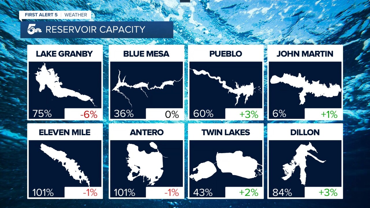
- Blue Mesa, the largest reservoir in Colorado, is still only at 36% capacity
As mentioned at the top of this story, Colorado has roughly one month until the typical peak in our state's snowpack.
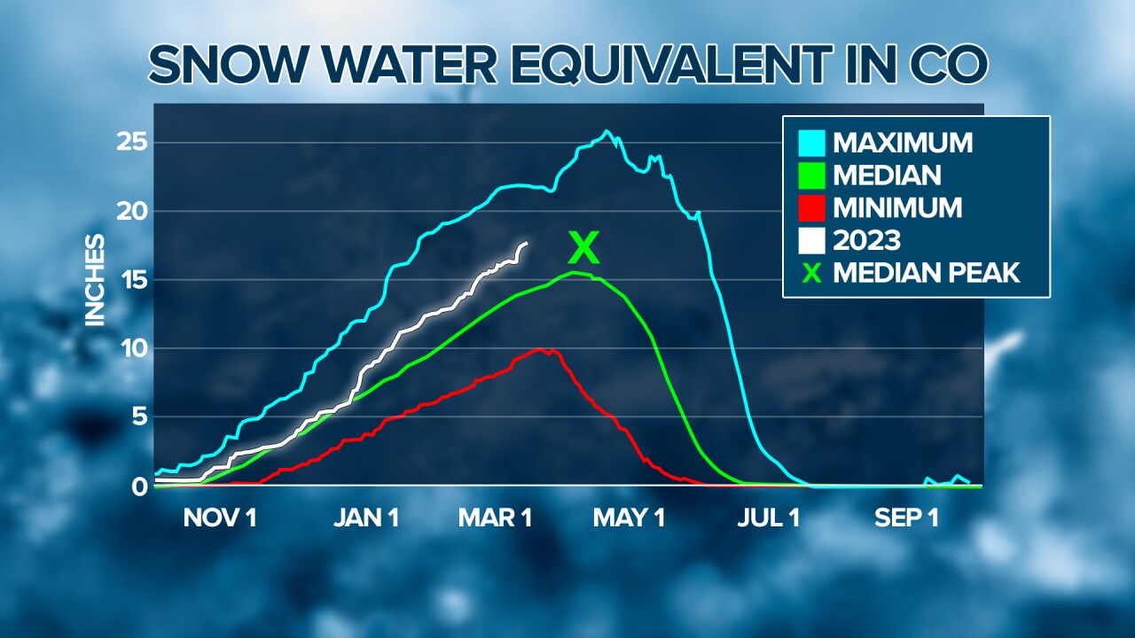
SNOTEL sites measure snowpack by melting the snow down and recording liquid water content.
When we look at a SNOTEL graph, we want the white line to be above the green line for a good snow year.
According to the statewide SNOTEL data, we've stayed at or above the median for most of the season! Colorado is sporting a healthy snowpack as we move closer to Spring.

The Yampa & White, Gunnison, and San Juan/Dolores basins have had the strongest snowpack of the season.
Unfortunately for southern Colorado, the Arkansas Basin continues to display the lowest snowpack in the state.
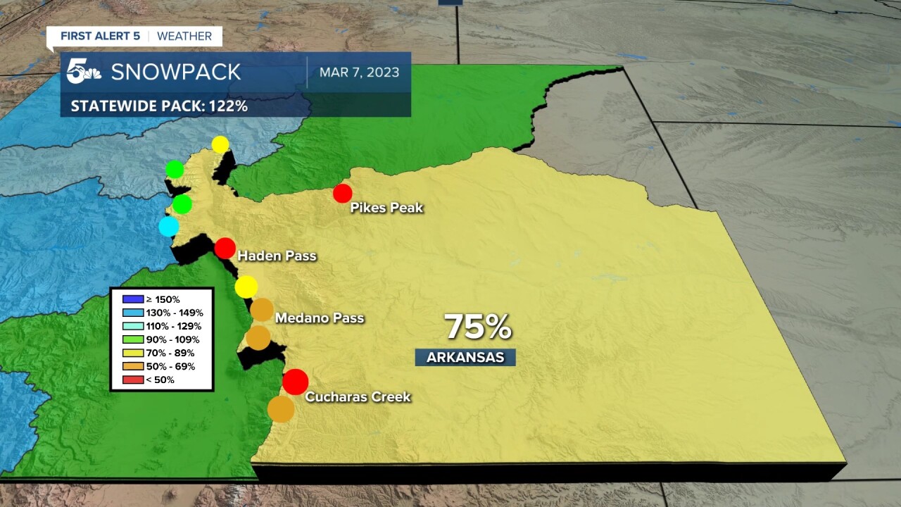
The Arkansas Basin SNOTEL sites are located up around Leadville, Buena Vista, down the Sangre De Cristos, and up on Glen Cove by Pikes Peak.
Snowpack measurements are great near Twin Lakes and St. Elmo, but poor near Pikes Peak and the Sangre De Cristos.
The concern here is that we only have around 30 days left until our median peak snowpack. After that, snowmelt will outpace snow accumulation up in the mountains.
Years with low snowpack are associated with drought, wildfires, and low reservoirs downstream.
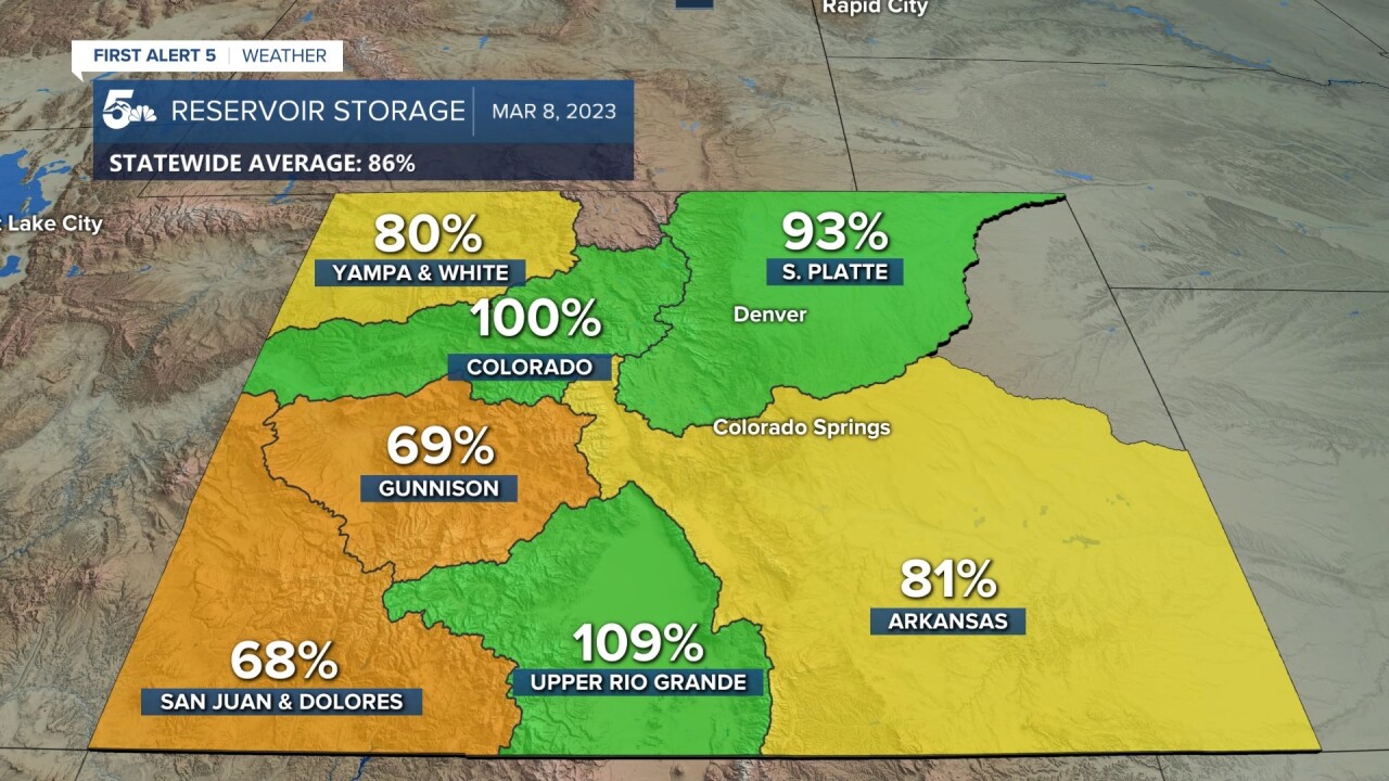
Speaking of reservoirs, things could certainly be better.
Displayed above is the reservoir storage for each basin in Colorado as a percent of the median for the last 30 years.
If statistics class was a little too long ago and the median sounds tricky, just look for basins at or above 100%.
Basins at or above 100% mean most of the reservoirs being measured are as full or fuller than expected for early March.
When comparing reservoir change from February to March, some fell and some grew.
Lake Granby, the headwaters of the Colorado River, fell by 6 percent capacity over the last month. Blue Mesa, the largest reservoir in the state, saw no change in capacity.
The John Martin Reservoir, the largest reservoir in the eastern plains and a primary source of irrigation, saw growth of just 1 percent from last month.
According to Dan Kirmer, park manager for John Martin Reservoir State Park, capacity below 10% is becoming all too common.
"During the last season we slipped down near 3%, and in 2014 levels were lower still. 2015 brought an amazing water year, with significant rainfall from April through June levels rose not only at John Martin Reservoir but along the entire lower Arkansas Valley. As an irrigation reservoir, we continue the downward trend regularly and only have a window (November through April) in the winter for storage."
____
Curious about the First Alert 5 Weather Storm Impact Scale? Check out our cheatsheet explainer.
Watch KOAA News5 on your time, anytime with our free streaming app available for your Roku, FireTV, AppleTV and Android TV. Just search KOAA News5, download and start watching.
