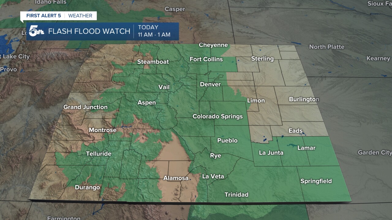
SOUTHERN COLORADO — This blog will be updated periodically with the forecast and impacts of severe weather and flash flooding on July 31, 2021
5:40 p.m. | El Paso County Flash Food Warning has been expanded to include most of Colorado Springs.
#BREAKING The El Paso County Flash Flood Warning has been expanded to include most of the Colorado Springs metro area. Between 2-3" of rain has fallen in some areas, with more expected. #cowx pic.twitter.com/NNs43V8C9b
— Alan Rose (@AlanRoseWX) July 31, 2021
5:25 p.m. | Flash flood watches in effect until 1 a.m. Sunday.
With Flash Flood Watches in effect until 1 am Sunday, here's some flash flood safety information and tips to keep in mind. Tonight's threat may also impact urban areas. #cowx pic.twitter.com/TMfaOyeu4A
— Alan Rose (@AlanRoseWX) July 31, 2021
4:35 p.m. | Reports of flooding in Colorado Springs. Use caution.
Hearing multiple reports of flooding on the south side of Colorado Springs, near Fountain & Circle. Please be careful out there folks. It only takes 6" of water to sweep a grown adult off of their feet. #cowx pic.twitter.com/6SO9x5QYEX
— Alan Rose (@AlanRoseWX) July 31, 2021
3:35 p.m. | Expect more widespread rain this evening.
Just past the bottom of the hour and rain showers are beginning to percolate over the Pikes Peak Region. Rain will become more widespread this evening, with the potential for heavy rain in some areas. #cowx pic.twitter.com/NRWJBIyoOS
— Alan Rose (@AlanRoseWX) July 31, 2021
3:30 p.m. | Heavy rain in Trinidad. Expect some flooding.
Seeing heavy rain right now in the Trinidad area. Expect minor street flooding, as well as flooding near some I-25 underpasses. #cowx pic.twitter.com/dd3jhiVj0K
— Alan Rose (@AlanRoseWX) July 31, 2021
2:40 p.m. | New Flash Flood Warning in Custer County.
A new Flash Flood Warning has just been issued for central Custer County. Radar estimated rainfall of 1-2" has been reported, with additional rain on the way. #cowx pic.twitter.com/VczFr9WdNA
— Alan Rose (@AlanRoseWX) July 31, 2021
2:30 p.m. | Heavy rain in Chaffee County has triggered a mudslide on Highway 285 at mile marker 125.
According to local law enforcement, heavy rain in Chaffee County has trigged a mudslide on Hwy 285 at mile marker 125, blocking the right lane. This is near Poncha Springs. #cowx pic.twitter.com/YZDsjeoDIM
— Alan Rose (@AlanRoseWX) July 31, 2021
1:50 p.m. | First Flash Flood Warning of the day for Southern Colorado has been issued near Coaldale.
This storm along Highway 50 near Coaldale has prompted a Flash Flood Warning. Main concerns in this area include: flooded out roadways and debris falling off of steep canyon walls. #cowx pic.twitter.com/0zJDymOljS
— Alan Rose (@AlanRoseWX) July 31, 2021
12:56 p.m. | Flash flood watch is now in effect
Thunderstorms are beginning to pop up over the mountains today. Flash flood watch is in effect now. #COwx pic.twitter.com/6YVkKzFzdp
— Alex O'Brien (@WXAlexOBrien) July 31, 2021
6:40 p.m. | South eastern plains will be on a Flash Flood Watch today
Additionally, the SE plains along and south of the Arkansas is included in the FLASH FLOOD WATCH. In our region, this will be in effect from 11 am to 1 am tonight. #COwx pic.twitter.com/bRdz6PS9C3
— Alex O'Brien (@WXAlexOBrien) July 31, 2021
Forecast:
On Saturday widespread, heavy rain will impact the state of Colorado. Showers will first develop in the mountains and slowly expand in coverage to the I-25 corridor and then the southeastern plains. Dangerous flash flooding will be the main threat today, with some storms capable of producing 1-3 inches of rain in a few hours.
When: The FLASH FLOOD WATCH for southern Colorado is in effect now until 1 am. The threat will move from the mountains to the plains throughout the duration of the event. For metro areas along I-25, the timing will be from noon until 9 pm.
Hazards: Wildfire burn scars will be most susceptible to flash flooding. But, torrential rainfall will be capable of producing flash flood conditions in any creek, road, or urban area today. Lightning may be frequent. Hail should remain small and nonsevere. Wind gusts may be strong. Watch out for reduced visibility on the road. Mudslides or rockslides are possible in the mountains. Remember to turn around, don't drown if you approach a flooded road.
Stay advised: Keeping up with the latest, like this blog, is a great start. Having radar on your cell phone with the First Alert5 app can help you track storms on the go. FLASH FLOOD WARNINGS are a part of the emergency alert system and will alert you of a warning in your area. Be sure to turn on emergency alerts in your smartphone settings. Going somewhere without cell service? Bring a NOAA weather radio to receive life-saving alerts.
LIVE: Traffic map with the latest updates
Resources:
- Your latest First Alert 5 Weather Forecast
- School closing and delay list
- DIA Delays / FlyCOS Delays
- Watch News5 LIVE newscasts
_____
KOAA News5 on your time, streaming on your Roku, FireTV, AppleTV and AndroidTV.
News5 App | First Alert 5 Weather App
Youtube | Facebook | Instagram | Twitter


