


The much hyped snow is still forecast to hit Colorado Friday night through Saturday morning!
It'll start Friday afternoon over the mountains and up in Denver before pushing south in the evening.

Winter Storm Warnings will go into effect over northern El Paso and Teller counties, as well as the I-25 gap from Monument up into Denver on noon Friday until 6 pm Saturday.
The worst snow will fall west of I-25 near Boulder and Rocky Mountain National Park, but the Rampart Range here locally could easily see over 1 foot.
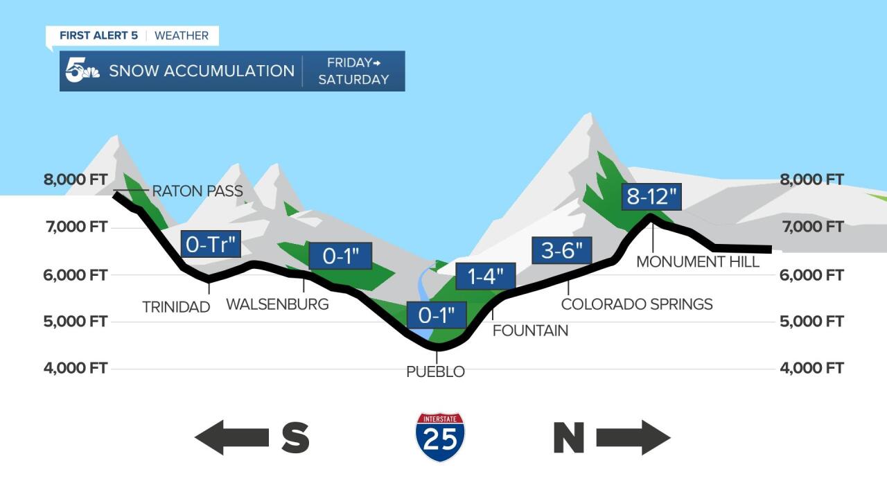
Along I-25, the heaviest snow accumulation will occur in northern El Paso County, generally as elevations get closer to 7,000 feet.
A combination of lift from the Palmer Divide and Monument Hill and colder air will increase snow production up around Monument, Black Forest, and Palmer Lake.

Region-wide, snow may fall to elevations as low as 5,000 feet in cities like Pueblo and Canon City, but warm air will prevent much if any snow accumulation on the ground.
Elevated metal surfaces, such as patio furniture or cars parked outside have the best chance for snow accumulation, not only in the Pikes Peak Region but down in Pueblo and Fremont counties.
Snow behavior in the Wet Mountain Valley will be a bit more unpredictable, but we think Westcliffe could see anywhere from 2 to 5 inches.

The most challenging forecast will be El Paso and Teller Counties. These are the two areas where the most snow is forecast Friday night through early Saturday morning.
The ground will be very warm (especially after Thursday's 90 degree weather), so a lot of this snow will try and melt as soon as it hits the ground. Some of you will likely have more snow fall in your yard than what you can actually measure by Saturday morning.
Northern El Paso County is going to be the bullseye for heavy snow. The west side of town and Manitou Springs could easily see 5 to 6 inches, but up by Monument, Black Forest, and Palmer Lake, we have a much better shot of a foot of snow!
The biggest accumulations will occur over the Rampart Range, and west into Teller County. Woodland Park will have a very good shot of AT LEAST a foot of snow, if not more through Saturday morning. Cripple Creek and the High Park Fire should expect at least 10 inches on the low end of our forecast totals.
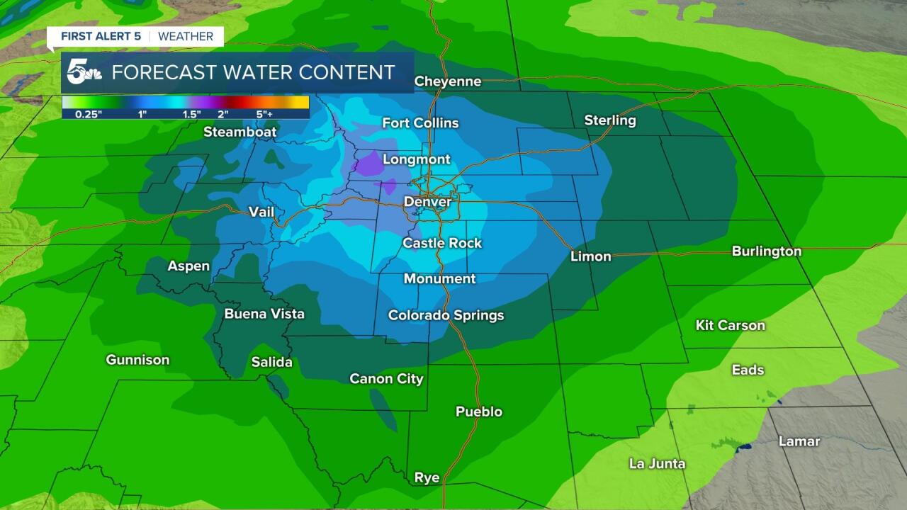
Snow in May is often very wet and heavy, usually because of the high moisture content.
1 to 2 inches of liquid water is forecast Teller County, as well as central to northern El Paso County.
Heavy snow like this will likely tear down tree limbs and possibly lead to power outages Friday night.

It's planting season, so if you've already got flowers and vegetables in the ground, you'll want to cover them Friday night.
Plastic works ok, but the best way to do it is either bring the pot inside or use something like a blanket or a towel.
With temperatures just barely at freezing along the I-25 corridor, plastic will likely work just fine, same with a tarp.

A harder freeze is possible Saturday night, so our advice is to either bring the plants inside once again, or cover them with a towel, blanket, or a heavier plastic, such as a tarp.
Follow our KOAA Weather Team for forecast updates throughout the day: https://www.koaa.com/weather
