

Colorado finally remembered how to snow!
Multiple snow storms over the last couple of months have erased almost all drought across the mountains with dramatic improvement across the plains.
Use this slider to compare the drought monitor from December 20th to January 17th.
The mountains have seen the biggest and clearest reduction in drought over the last 30 days. Moderate drought remains extensive over the plains, but notable improvement has been made in the last 30 days.
Ski Area Snow Totals since December 1st:
Estimates from Open Snow show ski areas across Colorado seeing anywhere from 90 to almost 200 inches of snow since December 1st!
| Steamboat | 181" |
| Breckenridge | 96" |
| Vail | 125" |
| Crested Butte | 125" |
| Monarch Mountain | 109" |
| Telluride | 99" |
| Wolf Creek Ski Area | 174" |
East of I-25, the biggest reduction has been in severe drought. We're still moisture-starved east of I-25, but widespread moderate drought is much better than severe drought.
As drought severity decreases, wildfire threats decrease. Local ponds and rivers see an increase in water availability, and warm-season water bills go down for farmers and ranchers.
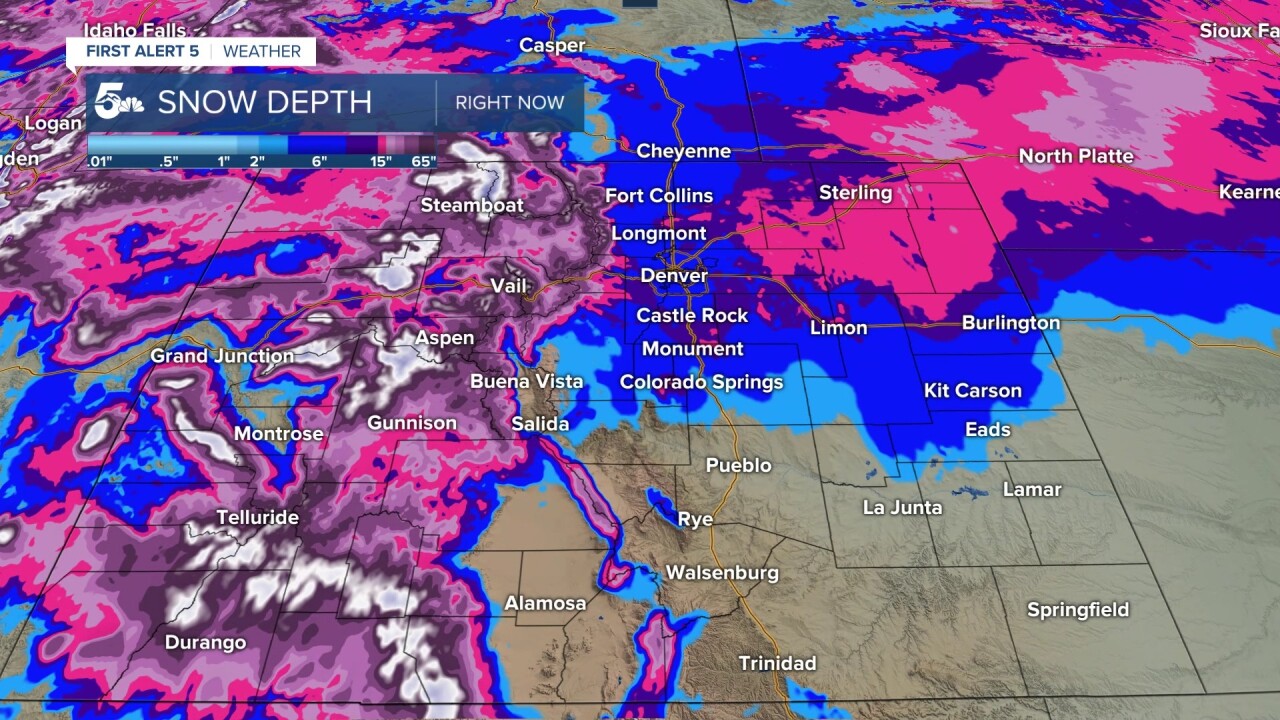
Snow depth is a modeled product using forecast data to overlay an estimation of unmelted snow across the United States.
Recent snow storms in January have left an approximate snow depth of 2 to 20 inches across the Pikes Peak Region, Denver metro, and most of the plains east of Denver!
For the mountains, snow depth ranges from a foot in the lower elevations to over 100 inches near Rabbit Ears Pass east of Steamboat!

SNOTEL sites placed across the mountains offer a more accurate reading of Colorado's current snowpack.
These numbers represent the snow-water equivalent percentage of normal.
The simple way to read a snowpack map is to look where the numbers are 100% or greater. Anything over 100% means there is an above-normal snowpack for that time of year, while anything below 100% is below normal.
As of January 19th, Colorado is actually doing quite well with 7 out of 8 river basins showing above-normal snowpack! The Arkansas River Basin that feeds Colorado Springs and Pueblo is about 15% below normal for mid-January.
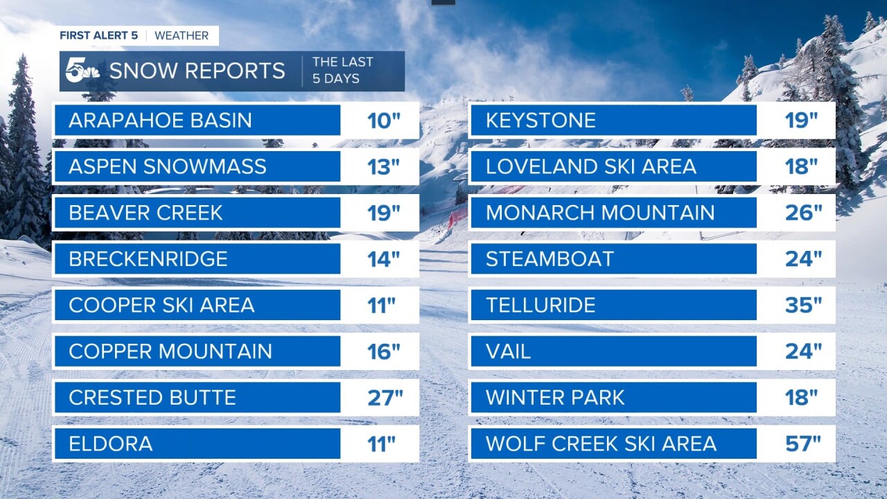
The most recent storm to hit Colorado from Monday the 16th through Wednesday the 18th left massive snow across most of the ski areas!
Most resorts managed somewhere between 1 to 2 feet of snow in three days. Members of the "2 feet in three days club" are Crested Butte, Monarch Mountain, Steamboat, Vail, and Telluride!
The king of the mountain was Wolf Creek Ski Area. In just 3 and a half days, 57 inches of snow was recorded by the Wolf Creek Ski Patrol.
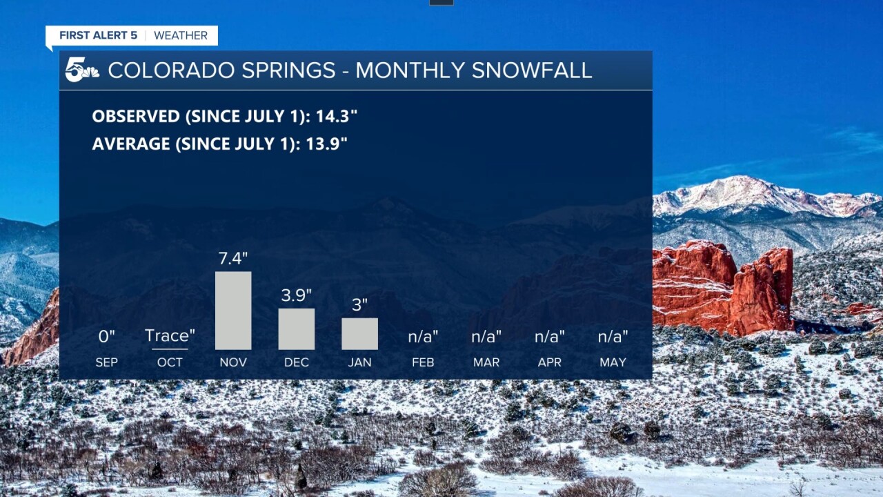
Snow totals across Colorado Springs have hovered just around average for the 2022/2023 snow season.
Keep in mind, our climate point for the city is located at the airport, so those of you in Briargate or north to Monument have likely see way more snow over the last few months!

For Pueblo, November was our big snow month with a dramatic shut-off through December and January.
We are running around 7 inches below normal for this time of year in Pueblo. A storm Friday night through Saturday could boost us at least a little closer to normal, but it seems likely Pueblo will be at or behind normal through the rest of winter.
