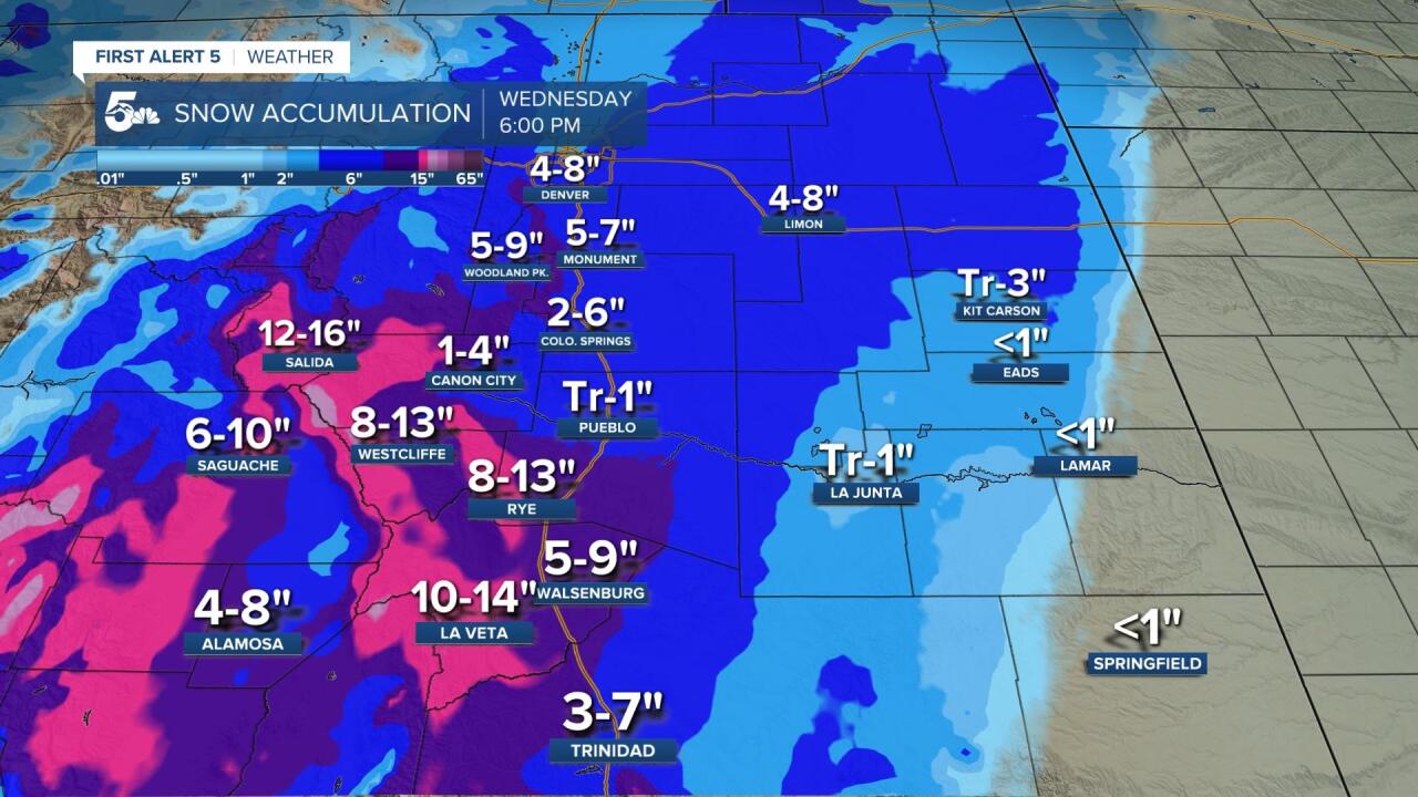
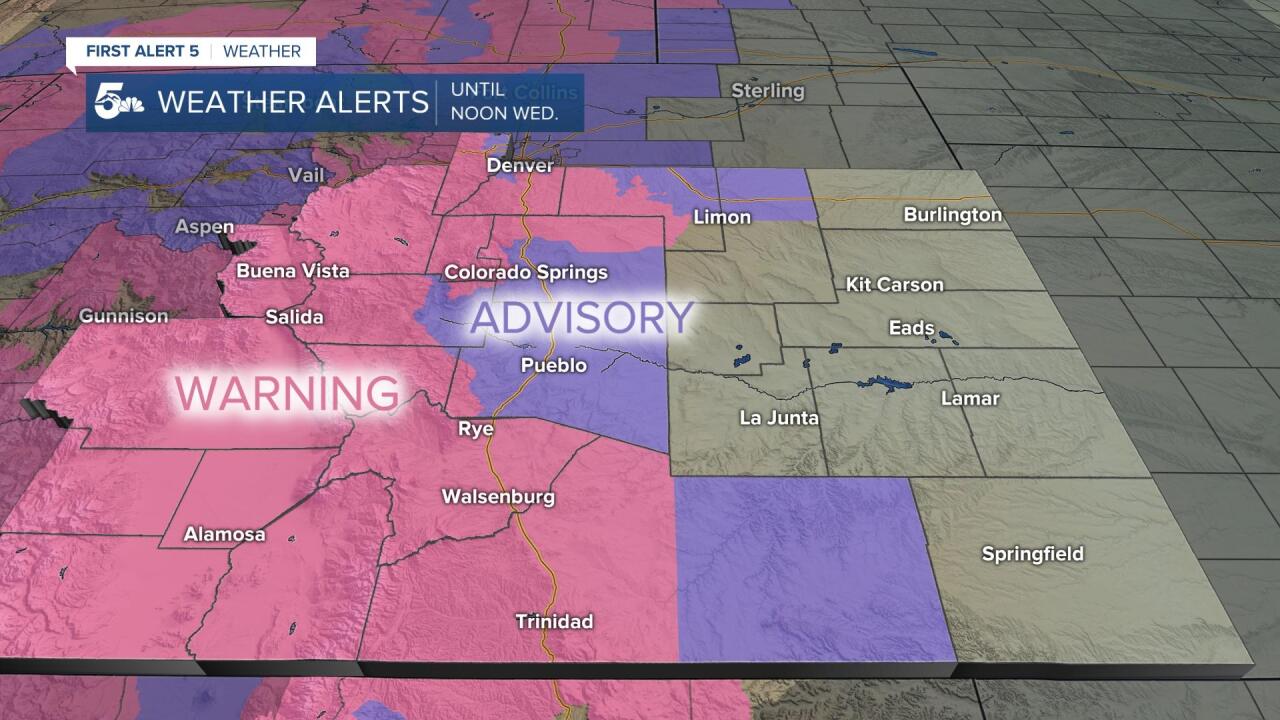
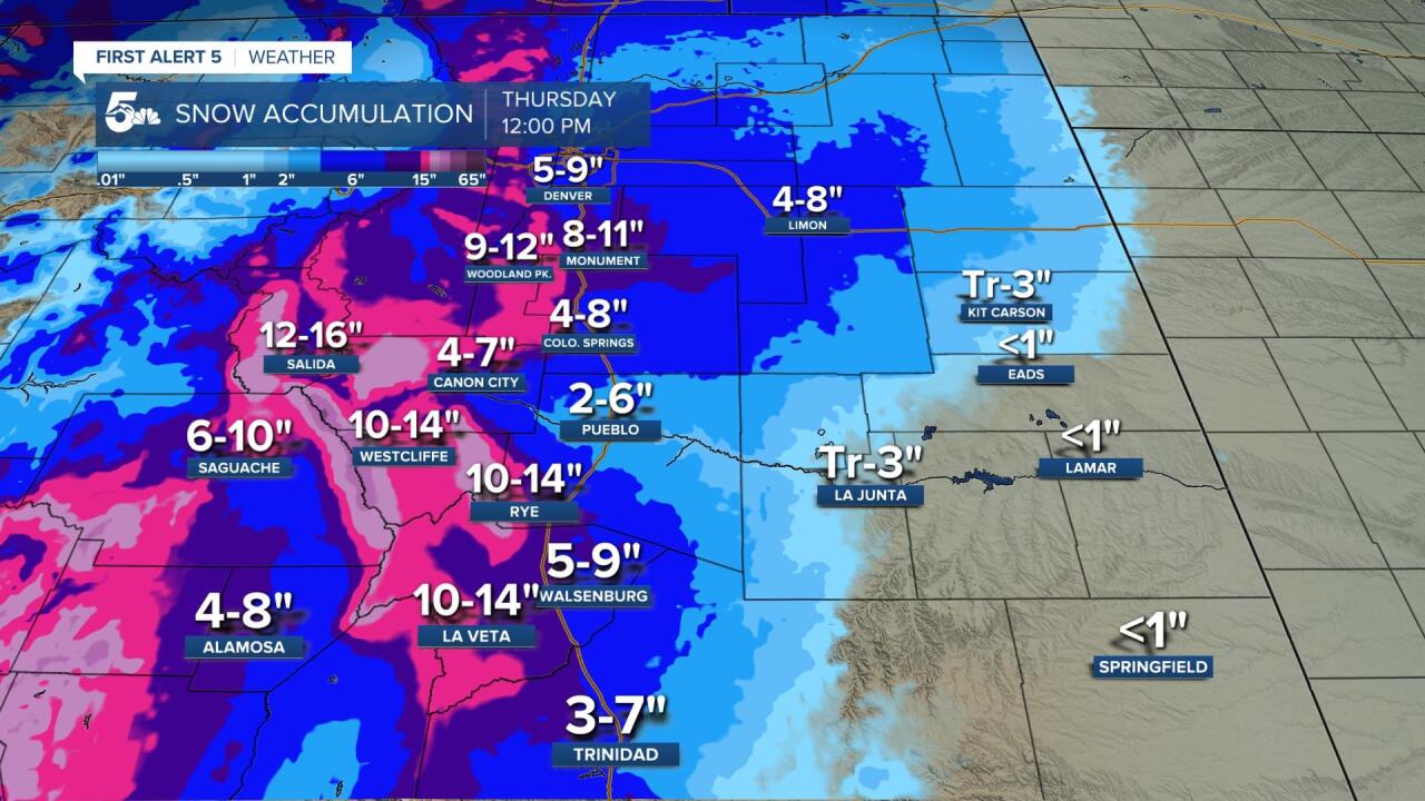
A large winter storm will bring wintry weather conditions, with impacts to our roadways through Wednesday morning.
10:20 p.m. Latest weather forecast
9:30 p.m. Current closures and delays for Wed.
- Woodland Park Re-2: Closed (Effective tomorrow - Wed Sep 9th)
- Pikes Peak Christian School: 10AM Delayed Start (Effective tomorrow - Wed Sep 9th)
- 4th Judicial District - Teller Co. Combined Courts: Opening at 10 am. Teller County Courthouse only. El Paso County Courthouse scheduled to open at 7:30 am. (Effective tomorrow - Wed Sep 9th)
- Cripple Creek-Victor: 2 Hours Late
- The Colorado Springs School: Closed. e-Learning Day (Effective tomorrow - Wed Sep 9th)
- Cotopaxi Fremont RE-3: Closed (Effective tomorrow - Wed Sep 9th)
- CEC Colorado Springs: All offices closed. CECCS staff will work from home. No in-person meetings, groups or tutoring. Classes as normal.
- Monument Acad. Charter Sch.: 2 Hours Late, No AM preschool. AM Kindie 10:10-2:10 (Effective tomorrow - Wed Sep 9th)
9:09 p.m. Update on snow in Monument
Quick update on conditions from Monument. @KOAA pic.twitter.com/3s1OoPnzKX
— Spencer Humphrey (@SHumphreyTV) September 9, 2020
7:52 p.m. No accumulation yet in Pueblo
Rain starting to mix with a few wet snowflakes here at WFO Pueblo. Air temps is still 38F, so no accumulation yet.
— NWS Pueblo (@NWSPueblo) September 9, 2020
7:05 p.m. Homeless shelters juggle cold weather and coronavirus precautions
Coronavirus has already given homeless shelters enough to worry about, but with a freeze expected overnight, they have a lot on their plate. They now have to find a balance between bringing people in off the street, and protecting them from COVID-19.
6:40 p.m. Snow sticking in Monument
Right now in Monument, Colorado. Happy September! @KOAA pic.twitter.com/gumJca0QMJ
— Spencer Humphrey (@SHumphreyTV) September 9, 2020
6:10 p.m. Tracking snow as it moves across the state.
5:56 p.m. Latest snowfall forecast from Lead Forecaster Mike Daniels:

5:37 p.m. As expected, bands of heavier snow are forming over Teller County, the Palmer Divide, Pikes Peak Region and near the mountains. For now, precipitation is still falling as rain over Pueblo and Canon City.
Snowfall rates are really starting to ramp up, and will continue to do so from late tonight into early Wednesday morning. Notice that it's still rain that's falling in Canon City and Pueblo. #cowx pic.twitter.com/g4B0z5375i
— Alan Rose (@AlanRoseWX) September 8, 2020
5:10 p.m. Although some areas will be OK, tonight's cold temperatures and associated Freeze Warning could severely damage or even kill crops. Protect your at home garden and pets by covering up when you can, and bringing in the rest.
This storm will also bring the potential for a season ending freeze to many parts of Southern Colorado. The sooner the better when it comes to taking steps to protect your garden. Also, make sure that your pets are inside and safe! #cowx pic.twitter.com/zWAWgtcuby
— Alan Rose (@AlanRoseWX) September 8, 2020
3:55 p.m. From smoky skies and record heat this past weekend to this! Current temperatures are running between 40 and 60 degrees colder than this time yesterday.
Dramatic temperature drops this afternoon in Southern Colorado. Some areas are down nearly 60 degrees from this time yesterday. #cowx #Weatherwhiplash pic.twitter.com/u5HOBMCxIF
— Alan Rose (@AlanRoseWX) September 8, 2020
3:45 p.m. Watching some big, fat flakes coming down right now over Cripple Creek. This area could see as much as 8-12" of snow by midday Wednesday. Notice how it's not yet sticking to the streets.

2:15 p.m. Winter storm Warnings and Winter Weather Advisories are now in effect across a large part of the News 5 viewing area, and conditions will begin to go downhill through the afternoon and evening hours. Big accumulations are expected from this storm, especially for early September standards.

1:51 p.m. Snow is starting to increase in coverage and intensity around Gunnison, Chaffee and Saguache counties, and is now pushing into western Fremont County.
It's snowing pretty good right now From Monarch to Salida, with heavier snow beginning to push east into Fremont County.#cowx pic.twitter.com/ZOSgHq0Aui
— Alan Rose (@AlanRoseWX) September 8, 2020
11:42 a.m. Colorado has seen an incredible change in the last 24 hours with many places dropping 40 to 50 degrees since Monday afternoon.
40° drop in 12 hours... 89 at 3pm Monday to 46 at 3am Tuesday pic.twitter.com/8qnYlyqMmE
— Sam Schreier (@SamASchreier) September 8, 2020
11:00 a.m. There have been periods of rain and snow, but the majority of our snow is yet to come.

The bulk of our snow accumulation will show up later this afternoon and especially overnight as both the air and road temperatures drop even farther. We can expect slick and dangerous commutes tomorrow morning, particularly in and around mountain areas.
KOAA Facebook / KOAA Twitter / KOAA_5 Instagram
Latest First Alert 5 Weather forecast
School Closings & Delays
DIA Delays / FlyCOS Delays
Watch News5 LIVE newscasts
Download the News5 App
Download the First Alert 5 Weather App
Download the First Alert 5 Weather App


