Snow is coming to Colorado Wednesday, and while it certainly could be a large weather impact, there remains a lot of uncertainty in the modeling. This is why forecasting in the mountains can be so complicated.
“Mom, the weather models are arguing again!”
Take a look at the image above. The model on the left, Model 1, shows the entire interstate as well as the mountains and plains covered in a wide swath of snow, including a band of very heavy snow. The model on the right, Model 2, on the other hand, really only shows the Pikes Peak region and highlands getting snow.
What does the KOAA weather team think will happen?
Right now, we’re being very cautious about this system and not biting on huge snow totals. The European model has shown some of the most consistent patterns over the last couple of days, but we do think it’s showing too much snowfall.
Rain and snow will start showing up Wednesday morning, with rain in the southeast plains and snow out west of the Sangres and Front Range. As the day goes on, snow will start to fill into the Sangres, Wets and Front Range, but I-25 will likely remain dry from a dry slot in the low pressure system. The plains will continue to see periods of rain from the morning well into the afternoon.
As the evening rolls in, snow will start coming down harder over the mountains west of the interstate, and we’ll start to see a brief rain/snow mixture falling along I-25 that will turn quickly into snow, especially over Colorado Springs. Ice IS NOT expected to be a problem for the I-25 corridor. Snow will start falling harder in areas like the Palmer Divide and Colorado Springs as the night wears on, with shovel-able snow in place by Thursday morning.
The plains are going to see a switch from rain to freezing rain Wednesday evening and eventually snow overnight. Snow totals will vary greatest over the plains, depending on how quickly we switch rain over to snow.
What about snow totals?
Give us another 12 to 24 hours, and we should start having a much better idea of how much snow is going to fall. Right now, with how completely different our modeling is behaving, throwing numbers out there will be irresponsible and likely completely different than what we’ll be seeing tomorrow.
Big systems like these need time, patience, and caution as to not scare anyone. We want to be accurate, and sometimes that means waiting a bit.
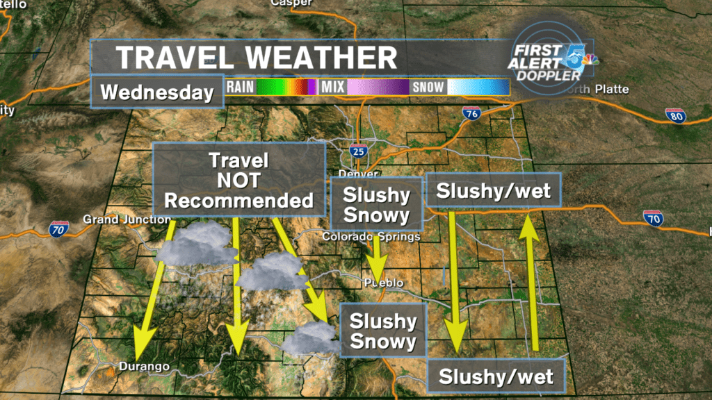
Travel Forecast:
The image below describes what to expect if you are on the roads Wednesday.
Any travel west of Pikes Peak and the Sangres will be dangerous and not advisable. Snow will easily be over a foot in most places along the Continental Divide and the plows will have difficulty keeping up with the snow, as it will be falling from Tuesday through Wednesday night.
Lighter snow will eventually fall on I-25 Wednesday evening through Thursday morning. While we aren’t expecting as much snow as the mountains, the roads will still become slick and dangerous Wednesday night.
The biggest risk over the plains will be freezing rain Wednesday evening that will then turn to slushy snow overnight. Black ice and ice buried under snow could become a major travel concern along highway 50 and 160.